A team of scientists take to the skies in one of the world’s largest airships, for a unique exploration of Earth’s most precious and mysterious environment – the atmosphere.
In an example of what might be called a massive change of topic from yesterday’s post on Integrity and democracy, today’s offering to you, dear reader, is about the magnificent atmosphere upon which we all depend.
Here’s a clue.
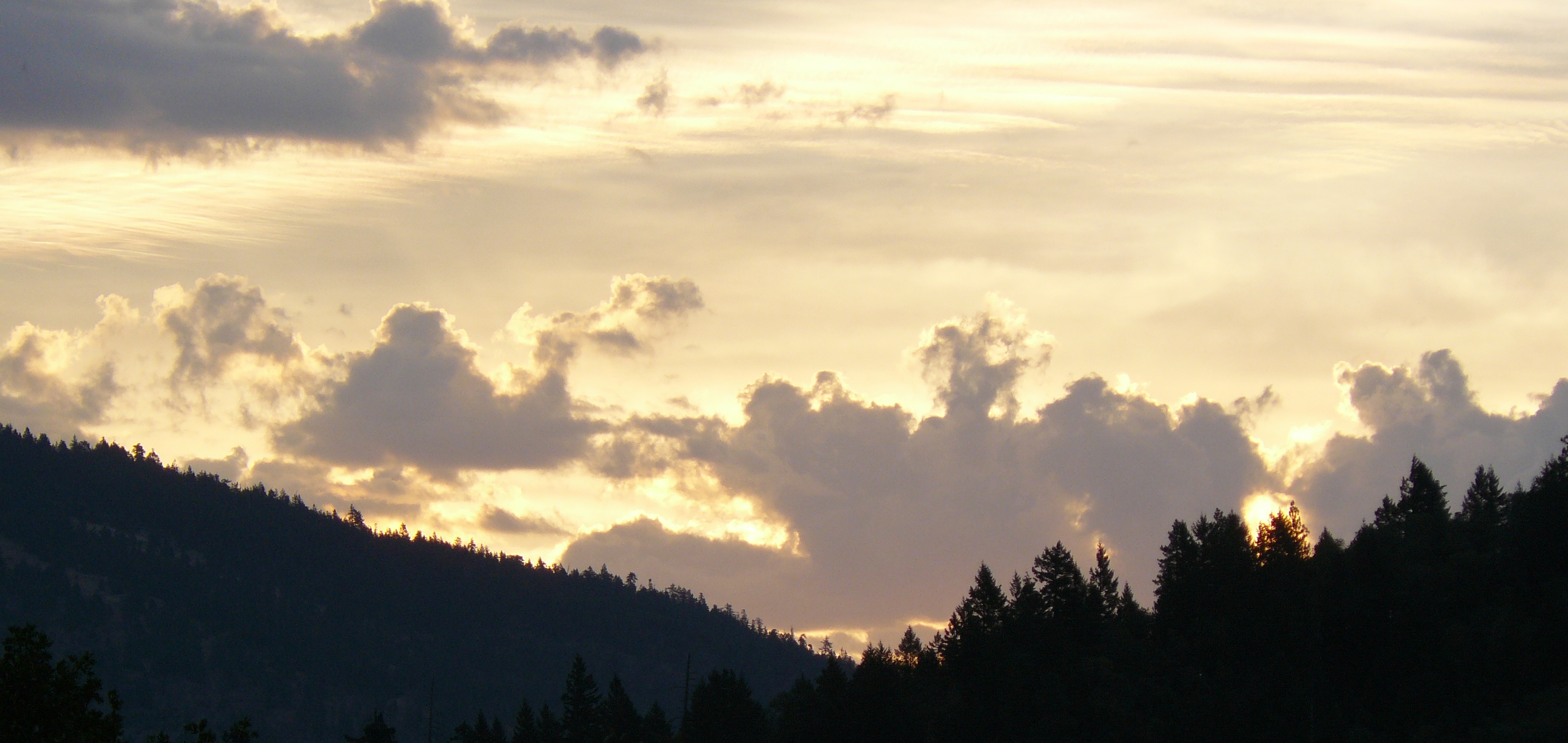
Sunrise to our North-East at a little after 7am on Sunday, 13th July, 2014.
Every Breath We Take: Understanding Our Atmosphere
The air around us is not just empty space; it is an integral part of the chemistry of life. Plants are made from carbon dioxide, nitrogen nourishes the soil and oxygen gives us the energy we need to keep our hearts pumping and our brains alive. But how did we come to understand what air is made of? How did we come to know that this invisible stuff around us contains anything at all?
Gabrielle Walker tells the remarkable story of the quest to understand the air. It’s a tale of heroes and underdogs, chance encounters and sheer blind luck that spans the entire history of science. It began as a simple desire to further our knowledge of the natural world, but it ended up uncovering raw materials that have shaped our modern world, unravelling the secrets of our own physiology and revealing why we are here at all.
There is much more to explore on the website, including this trailer to the programme.
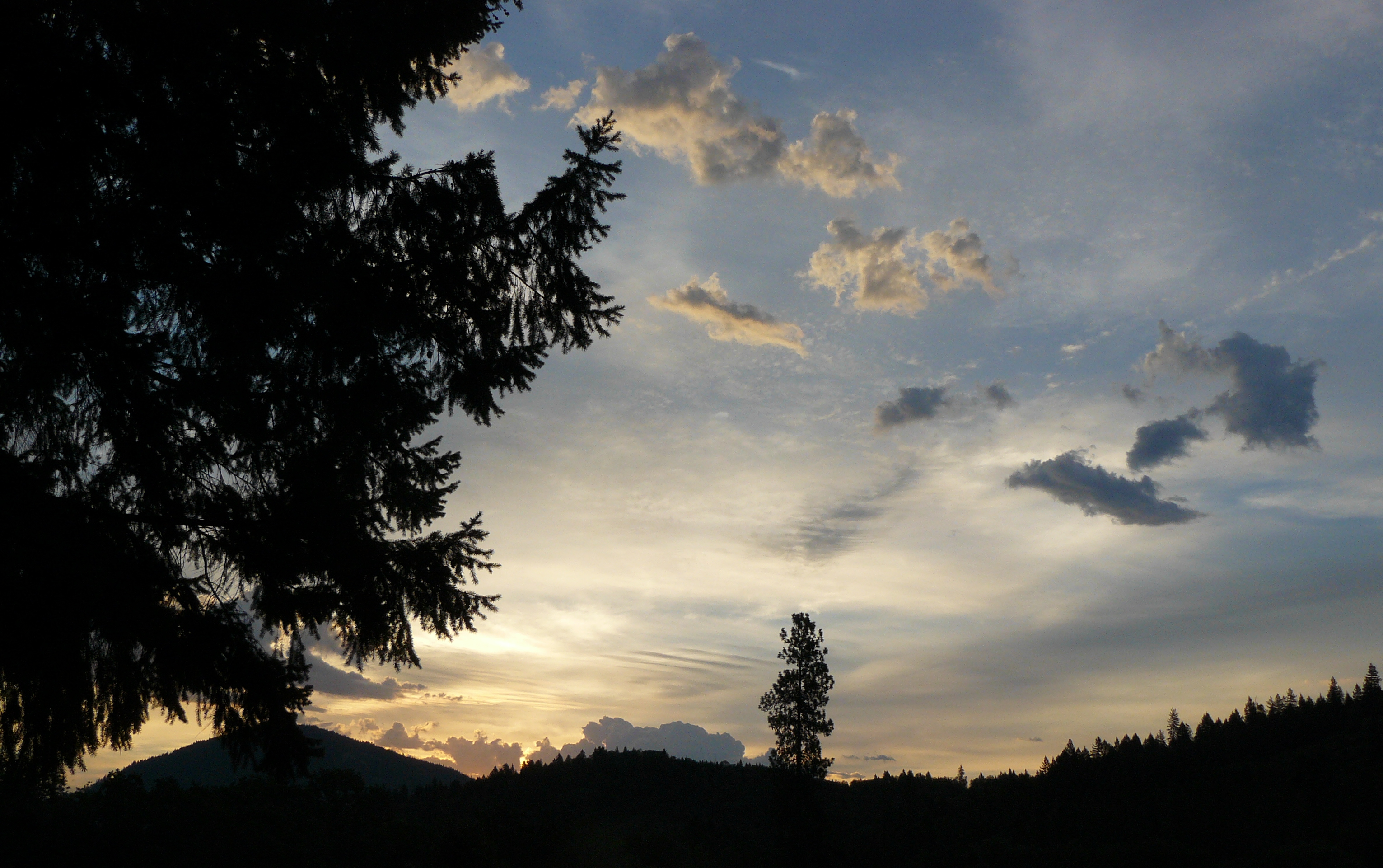
Oh, here’s another ‘clue’ from Oregon.
Same morning, same sunrise.
The presenter of the BBC series is Felicity Aston who writes on her BBC Blog:
I joined Operation Cloud Lab: Secrets Of The Skies as the expedition leader and also as a meteorologist.
The plan was to fly from Florida to California, looking at the science of the skies.
But as well as scientists, there were plenty of other people on the team including three pilots, a ground crew of 14 that followed the airship by road and a full production team including two camera crews. Not everyone could be on board at once – the airship would never have got off the ground!
But I was really fortunate to spend a lot of time on board and flew most of the way across the continent.
Exploring in three dimensions rather than being limited to making observations from the ground was a revelation to me.
The clouds in the tropics around the Gulf of Mexico are huge, and being in the sky with them really brought home the vast scale of the forces at work.
Towering cumulus cloud in Florida.
We were able to travel over, under and through these monsters, revealing that clouds are about as far from the popular image of light and fluffy floating puffs of cotton wool as you can get! They are dense and heavy and full of destructive energy.
I remember looking down at the cloud layer from a plane as a child, and daydreaming about exploring this new world of unknown places, so I was very excited the first time we flew straight through a cloud.
I leaned out of the airship as far as I dared into the heart of a cloud and found that it was a dark, damp mass of floating fog (of course!) – no mysterious worlds – my childhood fantasies were crushed!
There’s more to read on her blog as well as some stupendous photographs of clouds.
So if this gives you a thrill then don’t delay in watching the full-length Episode One on YouTube before it gets taken down. (Warning: if you watch the opening first few minutes you will be hooked for the full hour!)
Now to close with, yes you guessed it, my final ‘clue’ from Oregon.
A powerful essay by Tom Engelhardt from his blogsite TomDispatch.
Regular readers of Learning from Dogs know that essays from TomDispatch often find their way onto these pages. They are republished with the generous permission of Tom and I endeavour to select those essays that shine a new light on a current issue. No less so than with today’s essay, first published over on TomDispatch on May 22nd, 2014.
Just a note before you start reading Tom’s very important essay. That there are many links to papers, articles and other references throughout the essay. (I know, they took me a couple of hours to set up!) Could I recommend strongly that you ‘click’ on each link and make a note of the references you wish to read at a later time. I shall be referring to some of them next week when I comment more generally on this fabulous essay.
ooOOoo
Tomgram: Engelhardt, Is Climate Change a Crime Against Humanity?
Who could forget? At the time, in the fall of 2002, there was such a drumbeat of “information” from top figures in the Bush administration about the secret Iraqi program to develop weapons of mass destruction (WMD) and so endanger the United States. And who — other than a few suckers — could have doubted that Saddam Hussein was eventually going to get a nuclear weapon? The only question, as our vice president suggested on “Meet the Press,” was: Would it take one year or five? And he wasn’t alone in his fears, since there was plenty of proof of what was going on. For starters, there were those “specially designed aluminum tubes” that the Iraqi autocrat had ordered as components for centrifuges to enrich uranium in his thriving nuclear weapons program. Reporters Judith Miller and Michael Gordon hit the front page of the New York Times with that story on September 8, 2002.
Then there were those “mushroom clouds” that Condoleezza Rice, our national security advisor, was so publicly worried about — the ones destined to rise over American cities if we didn’t do something to stop Saddam. As she fretted in a CNN interview with Wolf Blitzer on that same September 8th, “[W]e don’t want the smoking gun to be a mushroom cloud.” No, indeed, and nor, it turned out, did Congress!
And just in case you weren’t anxious enough about the looming Iraqi threat, there were those unmanned aerial vehicles — Saddam’s drones! — that could be armed with chemical or biological WMD from his arsenal and flown over America’s East Coast cities with unimaginable results. President George W. Bush went on TV to talk about them and congressional votes were changed in favor of war thanks to hair-raising secret administration briefings about them on Capitol Hill.
In the end, it turned out that Saddam had no weapons program, no nuclear bomb in the offing, no centrifuges for those aluminum pipes, no biological or chemical weapons caches, and no drone aircraft to deliver his nonexistent weapons of mass destruction (nor any ships capable of putting those nonexistent robotic planes in the vicinity of the U.S. coast). But what if he had? Who wanted to take that chance? Not Vice President Dick Cheney, certainly. Inside the Bush administration he propounded something that journalist Ron Suskind later dubbed the “one percent doctrine.” Its essence was this: if there was even a 1% chance of an attack on the United States, especially involving weapons of mass destruction, it must be dealt with as if it were a 95%-100% certainty.
Here’s the curious thing: if you look back on America’s apocalyptic fears of destruction during the first 14 years of this century, they largely involved three city-busting weapons that were fantasies of Washington’s fertile imperial imagination. There was that “bomb” of Saddam’s, which provided part of the pretext for a much-desired invasion of Iraq. There was the “bomb” of the mullahs, the Iranian fundamentalist regime that we’ve just loved to hate ever since they repaid us, in 1979, for the CIA’s overthrow of an elected government in 1953 and the installation of the Shah by taking the staff of the U.S. embassy in Tehran hostage. If you believed the news from Washington and Tel Aviv, the Iranians, too, were perilously close to producing a nuclear weapon or at least repeatedly on the verge of the verge of doing so. The production of that “Iranian bomb” has, for years, been a focus of American policy in the Middle East, the “brink” beyond which war has endlessly loomed. And yet there was and is no Iranian bomb, nor evidence that the Iranians were or are on the verge of producing one.
Finally, of course, there was al-Qaeda’s bomb, the “dirty bomb” that organization might somehow assemble, transport to the U.S., and set off in an American city, or the “loose nuke,” maybe from the Pakistani arsenal, with which it might do the same. This is the third fantasy bomb that has riveted American attention in these last years, even though there is less evidence for or likelihood of its imminent existence than of the Iraqi and Iranian ones.
To sum up, the strange thing about end-of-the-world-as-we’ve-known-it scenarios from Washington, post-9/11, is this: with a single exception, they involved only non-existent weapons of mass destruction. A fourth weapon — one that existed but played a more modest role in Washington’s fantasies — was North Korea’s perfectly real bomb, which in these years the North Koreans were incapable of delivering to American shores.
The “Good News” About Climate Change
In a world in which nuclear weapons remain a crucial coin of the realm when it comes to global power, none of these examples could quite be classified as 0% dangers. Saddam had once had a nuclear program, just not in 2002-2003, and also chemical weapons, which he used against Iranian troops in his 1980s war with their country (with the help of targeting information from the U.S. military) and against his own Kurdish population. The Iranians might (or might not) have been preparing their nuclear program for a possible weapons breakout capability, and al-Qaeda certainly would not have rejected a loose nuke, if one were available (though that organization’s ability to use it would still have been questionable).
In the meantime, the giant arsenals of WMD in existence, the American, Russian, Chinese, Israeli, Pakistani, and Indian ones that might actually have left a crippled or devastated planet behind, remained largely off the American radar screen. In the case of the Indian arsenal, the Bush administration actually lent an indirect hand to its expansion. So it was twenty-first-century typical when President Obama, trying to put Russia’s recent actions in the Ukraine in perspective, said, “Russia is a regional power that is threatening some of its immediate neighbors. I continue to be much more concerned when it comes to our security with the prospect of a nuclear weapon going off in Manhattan.”
Once again, an American president was focused on a bomb that would raise a mushroom cloud over Manhattan. And which bomb, exactly, was that, Mr. President?
Of course, there was a weapon of mass destruction that could indeed do staggering damage to or someday simply drown New York City, Washington D.C., Miami, and other East coast cities. It had its own efficient delivery systems — no nonexistent drones or Islamic fanatics needed. And unlike the Iraqi, Iranian, or al-Qaeda bombs, it was guaranteed to be delivered to our shores unless preventive action was taken soon. No one needed to hunt for its secret facilities. It was a weapons system whose production plants sat in full view right here in the United States, as well as in Europe, China, and India, as well as in Russia, Saudi Arabia, Iran, Venezuela, and other energy states.
So here’s a question I’d like any of you living in or visiting Wyoming to ask the former vice president, should you run into him in a state that’s notoriously thin on population: How would he feel about acting preventively, if instead of a 1% chance that some country with weapons of mass destruction might use them against us, there was at least a 95% — and likely as not a 100% — chance of them being set off on our soil? Let’s be conservative, since the question is being posed to a well-known neoconservative. Ask him whether he would be in favor of pursuing the 95% doctrine the way he was the 1% version.
After all, thanks to a grim report in 2013 from the Intergovernmental Panel on Climate Change, we know that there is now a 95%-100% likelihood that “human influence has been the dominant cause of the observed warming [of the planet] since the mid-20th century.” We know as well that the warming of the planet — thanks to the fossil fuel system we live by and the greenhouse gases it deposits in the atmosphere — is already doing real damage to our world and specifically to the United States, as a recent scientific report released by the White House made clear. We also know, with grimly reasonable certainty, what kinds of damage those 95%-100% odds are likely to translate into in the decades, and even centuries, to come if nothing changes radically: a temperature rise by century’s end that could exceed 10 degrees Fahrenheit, cascading species extinctions, staggeringly severe droughts across larger parts of the planet (as in the present long-term drought in the American West and Southwest), far more severe rainfall across other areas, more intense storms causing far greater damage, devastating heat waves on a scale no one in human history has ever experienced, masses of refugees, rising global food prices, and among other catastrophes on the human agenda, rising sea levels that will drown coastal areas of the planet.
From two scientific studies just released, for example, comes the news that the West Antarctic ice sheet, one of the great ice accumulations on the planet, has now begun a process of melting and collapse that could, centuries from now, raise world sea levels by a nightmarish 10 to 13 feet. That mass of ice is, according to the lead authors of one of the studies, already in “irreversible retreat,” which means — no matter what acts are taken from now on — a future death sentence for some of the world’s great cities. (And that’s without even the melting of the Greenland ice shield, not to speak of the rest of the ice in Antarctica.)
All of this, of course, will happen mainly because we humans continue to burn fossil fuels at an unprecedented rate and so annually deposit carbon dioxide in the atmosphere at record levels. In other words, we’re talking about weapons of mass destruction of a new kind. While some of their effects are already in play, the planetary destruction that nuclear weapons could cause almost instantaneously, or at least (given “nuclear winter” scenarios) within months, will, with climate change, take decades, if not centuries, to deliver its full, devastating planetary impact.
When we speak of WMD, we usually think of weapons — nuclear, biological, or chemical — that are delivered in a measurable moment in time. Consider climate change, then, a WMD on a particularly long fuse, already lit and there for any of us to see. Unlike the feared Iranian bomb or the Pakistani arsenal, you don’t need the CIA or the NSA to ferret such “weaponry” out. From oil wells to fracking structures, deep sea drilling rigs to platforms in the Gulf of Mexico, the machinery that produces this kind of WMD and ensures that it is continuously delivered to its planetary targets is in plain sight. Powerful as it may be, destructive as it will be, those who control it have faith that, being so long developing, it can remain in the open without panicking populations or calling any kind of destruction down on them.
The companies and energy states that produce such WMD remain remarkably open about what they’re doing. Generally speaking, they don’t hesitate to make public, or even boast about, their plans for the wholesale destruction of the planet, though of course they are never described that way. Nonetheless, if an Iraqi autocrat or Iranian mullahs spoke in similar fashion about producing nuclear weapons and how they were to be used, they would be toast.
Take ExxonMobil, one of the most profitable corporations in history. In early April, it released two reports that focused on how the company, as Bill McKibben has written, “planned to deal with the fact that [it] and other oil giants have many times more carbon in their collective reserves than scientists say we can safely burn.” He went on:
The company said that government restrictions that would force it to keep its [fossil fuel] reserves in the ground were ‘highly unlikely,’ and that they would not only dig them all up and burn them, but would continue to search for more gas and oil — a search that currently consumes about $100 million of its investors’ money every single day. ‘Based on this analysis, we are confident that none of our hydrocarbon reserves are now or will become “stranded.”‘
In other words, Exxon plans to exploit whatever fossil fuel reserves it possesses to their fullest extent. Government leaders involved in supporting the production of such weapons of mass destruction and their use are often similarly open about it, even while also discussing steps to mitigate their destructive effects. Take the White House, for instance. Here was a statement President Obama proudly made in Oklahoma in March 2012 on his energy policy:
Now, under my administration, America is producing more oil today than at any time in the last eight years. That’s important to know. Over the last three years, I’ve directed my administration to open up millions of acres for gas and oil exploration across 23 different states. We’re opening up more than 75% of our potential oil resources offshore. We’ve quadrupled the number of operating rigs to a record high. We’ve added enough new oil and gas pipeline to encircle the Earth and then some.
Similarly, on May 5th, just before the White House was to reveal that grim report on climate change in America, and with a Congress incapable of passing even the most rudimentary climate legislation aimed at making the country modestly more energy efficient, senior Obama adviser John Podesta appeared in the White House briefing room to brag about the administration’s “green” energy policy. “The United States,” he said, “is now the largest producer of natural gas in the world and the largest producer of gas and oil in the world. It’s projected that the United States will continue to be the largest producer of natural gas through 2030. For six straight months now, we’ve produced more oil here at home than we’ve imported from overseas. So that’s all a good-news story.”
Good news indeed, and from Vladmir Putin’s Russia, which just expanded its vast oil and gas holdings by a Maine-sized chunk of the Black Sea off Crimea, to Chinese “carbon bombs,” to Saudi Arabian production guarantees, similar “good-news stories” are similarly promoted. In essence, the creation of ever more greenhouse gases — of, that is, the engine of our future destruction — remains a “good news” story for ruling elites on planet Earth.
Weapons of Planetary Destruction
We know exactly what Dick Cheney — ready to go to war on a 1% possibility that some country might mean us harm — would answer, if asked about acting on the 95% doctrine. Who can doubt that his response would be similar to those of the giant energy companies, which have funded so much climate-change denialism and false science over the years? He would claim that the science simply isn’t “certain” enough (though “uncertainty” can, in fact, cut two ways), that before we commit vast sums to taking on the phenomenon, we need to know far more, and that, in any case, climate-change science is driven by a political agenda.
For Cheney & Co., it seemed obvious that acting on a 1% possibility was a sensible way to go in America’s “defense” and it’s no less gospel for them that acting on at least a 95% possibility isn’t. For the Republican Party as a whole, climate-change denial is by now nothing less than a litmus test of loyalty, and so even a 101% doctrine wouldn’t do when it comes to fossil fuels and this planet.
No point, of course, in blaming this on fossil fuels or even the carbon dioxide they give off when burned. These are no more weapons of mass destruction than are uranium-235 and plutonium-239. In this case, the weaponry is the production system that’s been set up to find, extract, sell at staggering profits, and burn those fossil fuels, and so create a greenhouse-gas planet. With climate change, there is no “Little Boy” or “Fat Man” equivalent, no simple weapon to focus on. In this sense, fracking is the weapons system, as is deep-sea drilling, as are those pipelines, and the gas stations, and the coal-fueled power plants, and the millions of cars filling global roads, and the accountants of the most profitable corporations in history.
All of it — everything that brings endless fossil fuels to market, makes those fuels eminently burnable, and helps suppress the development of non-fossil fuel alternatives — is the WMD. The CEOs of the planet’s giant energy corporations are the dangerous mullahs, the true fundamentalists, of planet Earth, since they are promoting a faith in fossil fuels which is guaranteed to lead us to some version of End Times.
Perhaps we need a new category of weapons with a new acronym to focus us on the nature of our present 95%-100% circumstances. Call them weapons of planetary destruction (WPD) or weapons of planetary harm (WPH). Only two weapons systems would clearly fit such categories. One would be nuclear weapons which, even in a localized war between Pakistan and India, could create some version of “nuclear winter” in which the planet was cut off from the sun by so much smoke and soot that it would grow colder fast, experience a massive loss of crops, of growing seasons, and of life. In the case of a major exchange of such weapons, we would be talking about “the sixth extinction” of planetary history.
Though on a different and harder to grasp time-scale, the burning of fossil fuels could end in a similar fashion — with a series of “irreversible” disasters that could essentially burn us and much other life off the Earth. This system of destruction on a planetary scale, facilitated by most of the ruling and corporate elites on the planet, is becoming (to bring into play another category not usually used in connection with climate change) the ultimate “crime against humanity” and, in fact, against most living things. It is becoming a “terracide.”
There are so many strong and fundamental points raised in this essay from Tom that I am going to return to them next week. (Will give it a rest for July 4th!)
This week is taking on a life of it’s own, so far as Learning from Dogs is concerned!
For when I penned Monday’s post, Running on Empty, I had not yet read George Monbiot’s essay Are We Bothered?. When I did so, it struck me as the perfect sequel to Monday’s post and formed the crux of yesterday’s post The nature of delusions. That second post also included a personal account of my delusion with regard to ocean sailing and seemed sufficiently wordy not to be extended by my further reflections.
Thus the decision to run over to a third day!
Let me offer, first of all, my own reflections to George Monbiot’s concerns. That I distill, using his words, to: “The more we consume, the less we care about the living planet.” Expanded in his concluding paragraph:
So the perennially low level of concern, which flickers upwards momentarily when disaster strikes, then slumps back into the customary stupor, is an almost inevitable result of a society that has become restructured around shopping, fashion, celebrity and an obsession with money. How we break the circle and wake people out of this dreamworld is the question that all those who love the living planet should address. There will be no easy answers.
When I first read Mr. Monbiot’s essay, I found myself nodding in agreement. Yet, upon further reflection, I became less sure that “a society that has become restructured around shopping, fashion, celebrity and an obsession with money.” was the core of the issue. I think it is a symptom.
Stay with me awhile I take a small deviation. To dogs, and other animals.
Many creatures have a powerful and instinctive means of assessing danger. One only needs to observe the wild black-tailed deer that frequent our property to know that the slightest hint of danger or the unknown has them dashing away to safety.
A young black-tailed deer seen at home last September.
Dogs are the same in that they will run early on from a danger.
Humans also have the propensity to be cautious about a clear and present danger. However, it’s my proposition that when the danger is unclear and when that danger threatens the very essence of who we are and the world that we have constructed around us, we can be blind to the point of madness. I can think of many examples in support of that thesis and I’m sure you can too.
Yes, we have “a society that has become restructured around shopping, fashion, celebrity and an obsession with money.” But I contend only because of the power of capitalism, of the power of modern marketing and advertising and the allure of being ‘one of the crowd’.
So back to my proposition. It is this.
That when our lives are threatened by something unclear, complex and, ultimately, of devastating impact, we are very reluctant to embrace it and even more reluctant to both embrace it and escape to safety; whatever the latter implies.
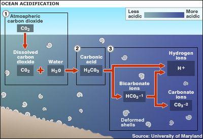
Mankind’s effect on the environment, the rising CO2 levels in the atmosphere, the increasing acidification of the oceans, the growing concerns about global weather, and on and on, are the most unclear, the most complex and the most devastating of futures to embrace.
(Thanks to Patrice for referring to this recently.)
So it really is no surprise to see mankind in general behaving as though this is a bit of a hangover, and an aspirin and a good night’s sleep will sort it! Especially when there is so much money and control invested in selling the same message; the message that there really is nothing to worry about.
There will be a so-called ‘tipping point’. A point in our awareness where the urgency to prevent the destruction of the biosphere will be paramount. And it will be a miracle if when that point arrives it isn’t far too late to save us.
I truly hope that I am wrong.
oooo
Remember what I wrote in yesterday’s post? About experiencing an Atlantic gale?
Fewer than 48-hours before my estimate of coming into Horta Marina on the Azores island of Faial, Songbird of Kent was struck by an early, fierce Winter gale. I seem to recall it was touching Force 10 Beaufort Scale (54 – 63 mph or 48 – 55 knots).
Anyway, it just about finished me off: literally as well as psychologically! I was so frightened, so utterly scared that I could think of nothing else other than getting to Horta and never going sailing again.
It revealed my delusion!
That was my ‘tipping point’ when it came to ocean sailing.
The gale subsided and I motor-sailed the 150-odd miles to Horta without any break for sleep or rest. Came into the harbour early in the morning after the second night since the gale. As soon as I was securely berthed, I closed the boat up and found a local hotel where a hot shower and a clean bed could restore a part of me.
Within a week, I had engaged a crew to sail the boat to Plymouth in South-West England and I flew back to England on a commercial airline.
Once Songbird of Kent arrived at Plymouth, she was put up for sale at a price that wouldn’t delay matters and that was that!
Oh, and I have never read any more books about single-handed ocean sailing. (But see my P.S.!)
oooo
P.S.
In yesterday’s post, I referred to Les Powells. Remember when I was in Larnaca, Cyprus? This is what I wrote:
Living on a boat close to me was Les Powles. Many will not have heard of Les but this quiet, softly-spoken man knows a thing or two about solo ocean sailing. As an article in The Guardian newspaper explained (in part):
In the 1980s and 90s a British man called Les Powles sailed three times round the world – always single-handedly, once non-stop. He couldn’t afford a radio transmitter, and on his greatest adventure he didn’t speak to anyone for 329 days. At 84, his circumnavigating days are now behind him, but he still lives on his boat, the Solitaire. What’s the appeal of sailing, I asked him. “It’s the solitude. When you’re out at sea on your own, there’s no government or bankers to worry about. You’re not responsible to anyone but yourself.”
Three times around the world – solo!
Thus getting to know Les was a great inspiration in getting me over the hurdle of can I really do this! (Les once said to me “the first three days are the worst!”)
Anyway, I have discovered that Les is living happily on his boat in Lymington, England and has written a book about his sailing life.
It has been ordered and arrives today. This one will be read – from the comfort and safety of our rural home in Oregon!
(And a big thanks to Dan Gomez for sending it my way.)
ooOOoo
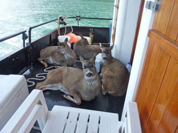
Went Fishing, Caught 4 Deer
A once in the history of mankind kind of thing. The Best Day Of Fishing Ever!
Some fishing stories are a little hard to believe but this guy has pictures to prove his story. Like me, you will heard of salmon jumping into boats, but never anything quite like this…
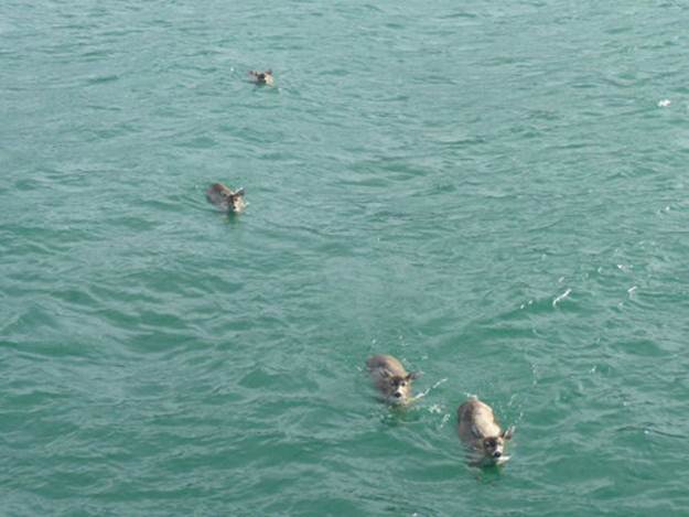
Tom Satre told the Sitka Gazette that he was out with a charter group on his 62-foot fishing vessel when four juvenile black-tailed deer swam directly toward his boat.
Once the deer reached the boat, the four began to circle the boat, looking directly at us. We could tell right away that the young bucks were distressed. I opened up my back gate and we helped the typically skittish and absolutely wild animals onto the boat. In all my years fishing, I’ve never seen anything quite like it! Once on board, they collapsed with exhaustion, shivering.
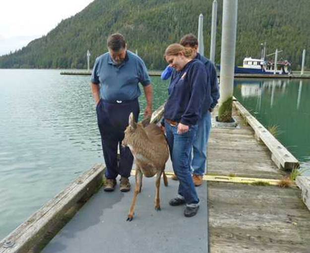
This is a picture I took of the rescued bucks on the back of my boat, the Alaska Quest. We headed for Taku Harbour. Once we reached the dock, the first buck that we had pulled from the water hopped onto the dock, looked back as if to say ‘thank you’ and disappeared into the forest. After a bit of prodding and assistance, two more followed, but the smallest deer needed a little more help.
This is me carrying the little guy.
oooo
My daughter, Anna, and son, Tim, helped the last buck to its feet. We didn’t know how long they had been in the icy waters or if there had been others who did not survive. My daughter later told me that the experience was something that she would never forget, and I suspect the deer felt the same way as well!”
“Kindness is the language the blind can see and the deaf can hear.” – Mark Twain
Story dated October, 2010
ooOOoo
I have no idea if it is a true story, although the photographs suggest it is, but so what! Any reminder of how precious our wild life is will always be welcomed on Learning from Dogs!
Cars travel through flood water in Helston, south-west Cornwall – Daily Mail August, 2013
You can tell, undoubtedly, from the title and sub-title to today’s post that I am feeling somewhat forlorn about the way that we humans work things out! As the old saying goes, “Question:Why has Planet Earth never been visited by an alien species?Answer:Because they have seen no signs of intelligent life!“
This feeling is a result of reading a recent essay from George Monbiot, Drowning in Money. It is republished here within his terms of sharing.
Now before you read it, if you are not living in the UK it would be easy to reject the messages as being only relevant to the United Kingdom. But when you do read it, you will agree that this level of government policy stupidity is not the sole reserve of the UK. The ‘virus’ is alive and well elsewhere!
ooOOoo
George Monbiot
Drowning in Money
January 13, 2014
The hidden and remarkable story of why devastating floods keep happening. By George Monbiot, published in the Guardian 14th January 2014.
We all know what’s gone wrong, or we think we do: not enough spending on flood defences. It’s true that the government’s cuts have exposed thousands of homes to greater risk, and that the cuts will become more dangerous as climate change kicks in (1). But too little public spending is a small part of problem. It is dwarfed by another factor, which has been overlooked in discussions in the media and statements by the government: too much public spending.
Vast amounts of public money – running into the billions – are spent every year on policies that make devastating floods inevitable. This is the story that has not been told by the papers or the broadcasters, a story of such destructive perversity that the Guardian has given me twice the usual space today in which to explain it.
Flood defence, or so we are told almost everywhere, is about how much concrete you can pour. It’s about not building houses in stupid places on the floodplain, and about using clever new engineering techniques to defend those already there (2). None of that is untrue, but it’s a small part of the story. To listen to the dismal debates of the past fortnight you could be forgiven for believing that rivers arise in the plains; that there is no such thing as upstream; that mountains, hills, catchments and watersheds are irrelevant to the question of whether or not homes and infrastructure get drowned.
The story begins with a group of visionary farmers at Pontbren, in the headwaters of Britain’s longest river, the Severn. In the 1990s they realised that the usual hill farming strategy – loading the land with more and bigger sheep, grubbing up the trees and hedges, digging more drains – wasn’t working. It made no economic sense, the animals had nowhere to shelter, the farmers were breaking their backs to wreck their own land.
So they devised something beautiful. They began planting shelter belts of trees along the contours. They stopped draining the wettest ground and built ponds to catch the water instead. They cut and chipped some of the wood they grew to make bedding for their animals, which meant that they no longer spent a fortune buying straw. Then they used the composted bedding, in a perfect closed loop, to cultivate more trees (3).
One day a government consultant was walking over their fields during a rainstorm. He noticed something that fascinated him: the water flashing off the land suddenly disappeared when it reached the belts of trees the farmers had planted. This prompted a major research programme, which produced the following astonishing results: water sinks into the soil under the trees at 67 times the rate at which it sinks into the soil under the grass (4). The roots of the trees provide channels down which the water flows, deep into the ground. The soil there becomes a sponge, a reservoir which sucks up water then releases it slowly. In the pastures, by contrast, the small sharp hooves of the sheep puddle the ground, making it almost impermeable: a hard pan off which the rain gushes.
One of the research papers estimates that, even though only 5% of the Pontbren land has been reforested, if all the farmers in the catchment did the same thing, flooding peaks downstream would be reduced by some 29% (5). Full reforestation would reduce the peaks by around 50% (6). For the residents of Shrewsbury, Gloucester and the other towns ravaged by endless Severn floods, that means, more or less, problem solved.
Did I say the results were astonishing? Well, not to anyone who has studied hydrology elsewhere. For decades the British government has been funding scientists working in the tropics, and using their findings to advise other countries to protect the forests or to replant trees in the hills, to prevent communities downstream from being swept away. But we forgot to bring the lesson home.
So will the rest of the Severn catchment, and those of the other unruly waterways of Britain, follow the Pontbren model? The authorities say they would love to do it (7). In theory. Natural Resources Wales told me that these techniques “are hard wired in to the actions we want land managers to undertake.” (8) What it forgot to say is that all tree planting grants in Wales have now been stopped. The offices responsible for administering them are in the process of closing down (9). If other farmers want to copy the Pontbren model, not only must they pay for the trees themselves; but they must sacrifice the money they would otherwise have been paid for farming that land.
For – and here we start to approach the nub of the problem – there is an unbreakable rule laid down by the Common Agricultural Policy. If you want to receive your single farm payment – by the far biggest component of farm subsidies – that land has to be free from what it calls “unwanted vegetation” (10). Land covered by trees is not eligible. The subsidy rules have enforced the mass clearance of vegetation from the hills.
Just as the tree planting grants have stopped, the land clearing grants have risen. In his speech to the Oxford Farming Conference, made during the height of the floods, the environment secretary Owen Paterson boasted that hill farmers “on the least-productive land” will now receive “the same direct payment rate on their upland farmland as their lowland counterparts.” (11) In other words, even in places where farming makes no sense because the land is so poor, farmers will now be paid more money to keep animals there. But to receive this money, they must first remove the trees and scrub that absorb the water falling on the hills.
And that’s just the start of it. One result of the latest round of subsidy negotiations – concluded in June last year – is that governments can now raise the special mountain payments, whose purpose is to encourage farming at the top of the watersheds, from €250 per hectare to €450 (12). This money should be renamed the flooding subsidy: it pays for the wreckage of homes, the evacuation of entire settlements, the drowning of people who don’t get away in time, all over Europe. Pig-headed idiocy doesn’t begin to describe it.
The problem is not confined to livestock in the mountains. In the foothills and lowlands, the misuse of heavy machinery, overstocking with animals and other forms of bad management can – by compacting the soil – increase the rates of instant run-off from 2% of all the rain that falls on the land to 60%(13).
Sometimes, ploughing a hillside in the wrong way at the wrong time of the year can cause a flood – of both mud and water – even without exceptional rainfall. This practice has blighted homes around the South Downs (that arguably should never have been ploughed at all). One house was flooded 31 times in the winter of 2000-2001 by muddy floods caused by ploughing (14). Another, in Suffolk, above which the fields had been churned up by pigs, was hit 50 times (15). But a paper on floods of this kind found that “there are no (or only very few) control measures taken yet in the UK.” (16)
Under the worst environment secretary this country has ever suffered, there seems little chance that much of this will change. In November, in response to calls to reforest the hills, Owen Paterson told parliament “I am absolutely clear that we have a real role to play in helping hill farmers to keep the hills looking as they do.” (17) (Bare, in other words). When asked by a parliamentary committee to discuss how the resilience of river catchments could be improved, the only thing he could think of was building more reservoirs (18).
But while he is cavalier and ignorant when it comes to managing land to reduce the likelihood of flooding, he goes out of his way to sow chaos when it comes to managing rivers.
Many years ago, river managers believed that the best way to prevent floods was to straighten, canalise and dredge rivers along much of their length, to enhance their capacity for carrying water. They soon discovered that this was not just wrong but counterproductive. A river can, at any moment, carry very little of the water that falls on its catchment: the great majority must be stored in the soils and on the floodplains.
By building ever higher banks around the rivers, by reducing their length through taking out the bends and by scooping out the snags and obstructions along the way, engineers unintentionally did two things. They increased the rate of flow, meaning that flood waters poured down the rivers and into the nearest towns much faster. And, by separating the rivers from the rural land through which they passed, they greatly decreased the area of functional floodplains (19, 20, 21).
The result, as authorities all over the world now recognise, was catastrophic. In many countries, chastened engineers are now putting snags back into the rivers, reconnecting them to uninhabited land that they can safely flood and allowing them to braid and twist and form oxbow lakes. These features catch the sediment and the tree trunks and rocks which otherwise pile up on urban bridges, and take much of the energy and speed out of the river. Rivers, as I was told by the people who had just rewilded one in the Lake District – greatly reducing the likelihood that it would cause floods downstream – “need something to chew on” (22, 23).
There are one or two other such projects in the UK: Paterson’s department is funding four rewilding schemes, to which it has allocated a grand total of, er, £1 million (24). Otherwise, the secretary of state is doing everything he can to prevent these lessons from being applied. Last year he was reported to have told a conference that “the purpose of waterways is to get rid of water” (25). In another speech he lambasted the previous government for a “blind adherence to Rousseauism” in refusing to dredge (26). Not only will there be more public dredging, he insists: but there will also be private dredging: landowners can now do it themselves (27).
After he announced this policy, the Environment Agency, which is his department’s statutory adviser, warned that dredging could “speed up flow and potentially increase the risk of flooding downstream.” (28) Elsewhere, his officials have pointed out that “protecting large areas of agricultural land in the floodplain tends to increase flood risk for downstream communities.” (29) The Pitt Review, commissioned by the previous government after the horrible 2007 floods, concluded that “dredging can make the river banks prone to erosion, and hence stimulate a further build-up of silt, exacerbating rather than improving problems with water capacity.” (30) Paterson has been told repeatedly that it makes more sense to pay farmers to store water in their fields, rather than shoving it off their land and into the towns.
But he has ignored all this advice and started seven pilot projects in which farmers will be permitted to drag all that messy wildlife habitat out of their rivers, to hurry the water down to the nearest urban pinch point (31). Perhaps we shouldn’t be surprised to discover that Paterson has demanded massive cuts at the Environment Agency, including many of the staff responsible for preventing floods (32).
Since 2007, there has been a review, a parliamentary enquiry, two bills, new flood management programmes (33), but next to nothing has changed. Floods, because of the way we manage our land and rivers, remain inevitable. We pay a fortune in farm subsidies and river-mangling projects to have our towns flooded and homes and lives wrecked. We pay again in the form of the flood defences necessitated by these crazy policies, and through the extra insurance payments – perhaps we should call them the Paterson tax – levied on all homes. But we also pay through the loss of everything else that watersheds give us: beauty, tranquility, wildlife and, oh yes, the small matter of water in the taps.
In the Compleat Angler, published in 1653, Izaac Walton wrote this. “I think the best Trout-anglers be in Derbyshire; for the waters there are clear to an extremity.” (34) No longer. Last summer I spent a weekend walking along the River Dove and its tributaries, where Walton used to fish. All along the river, including the stretch on which the fishing hut built for him by Charles Cotton still stands, the water was a murky blueish brown. The beds of clean gravel he celebrated were smothered in silt: on some bends the accretions of mud were several feet deep.
You had only to raise your eyes to see the problem: the badly-ploughed hills of the mid-catchment and above them the drained and burnt moors of the Peak District National Park, comprehensively trashed by grouse shooting estates. A recent report by Animal Aid found that grouse estates in England, though they serve only the super-rich, receive some £37m of public money every year in the form of subsidies (35). Much of this money is used to cut and burn them, which is likely to be a major cause of flooding (36). Though there had been plenty of rain throughout the winter and early spring, the river was already low and sluggish.
A combination of several disastrous forms of upland management has been helping Walton’s beloved river to flood, with the result that both government and local people have had to invest heavily in the Lower Dove flood defence scheme (37). But this wreckage has also caused it to dry up when the rain doesn’t fall.
That’s the flipside of a philosophy which believes that land exists only to support landowners, and waterways exist only “to get rid of water”. Instead of a steady flow sustained around the year by trees in the hills, by sensitive farming methods, by rivers which are allowed to find their own course and their own level, to filter and hold back their waters through bends and braiding and obstructions, we get a cycle of flood and drought. We get filthy water and empty aquifers and huge insurance premiums and ruined carpets. And all of it at public expense.
4. M. R. Marshall et al, 2013. The impact of rural land management changes on soil hydraulic properties and runoff processes: results from experimental plots in upland UK. Hydrological Processes, DOI: 10.1002/hyp.9826. http://onlinelibrary.wiley.com/doi/10.1002/hyp.9826/abstract
9. I talked to one of the employees over the weekend: everyone is being made redundant as all funding has ceased.
10. Official Journal of the European Union, 31st January 2009. Council Regulation (EC) No 73/2009 of 19 January 2009, establishing common rules for direct support schemes for farmers under the common agricultural policy and establishing certain support schemes for farmers, amending Regulations (EC) No 1290/2005, (EC) No 247/2006, (EC) No 378/2007 and repealing Regulation (EC) No 1782/2003. Annex III. http://eur-lex.europa.eu/LexUriServ/LexUriServ.do?uri=OJ:L:2009:030:0016:0016:EN:PDF
15. R. Evans, 2010. Runoff and soil erosion in arable Britain: changes in perception and policy since 1945. Environmental Science and Policy 13, pp 1 4 1 – 1 4 9. doi:10.1016/j.envsci.2010.01.001
23. I hope before long to write up the extraordinary story I was told by a representative of United Utilities about the sharply differing responses of the rewilded River Liza in Ennerdale and the still-canalised St John’s Beck in Thirlmere to the famous 2009 downpour.
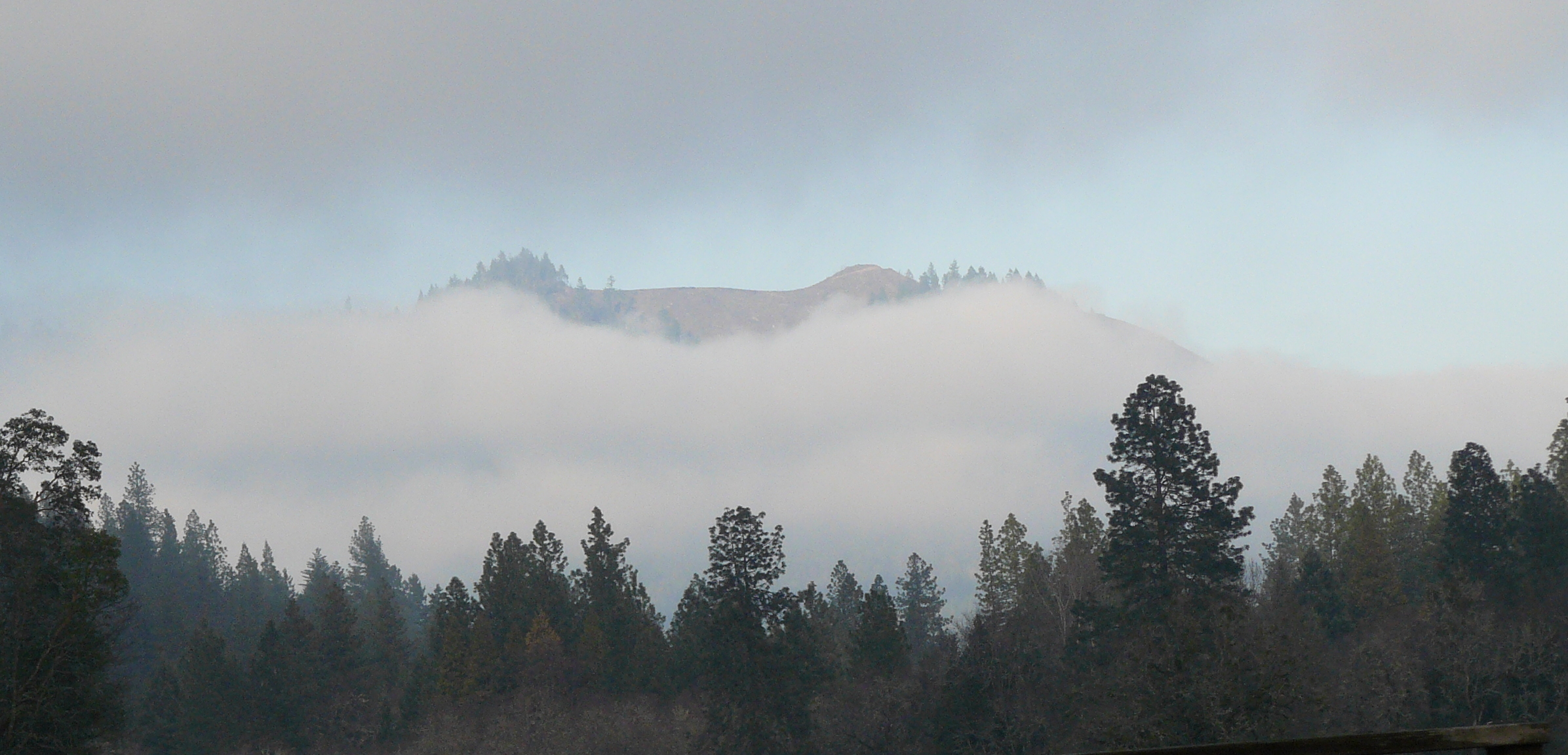
Just to underline that message of it not being only the UK with crazy policies, the photograph below is of a forest ridge within sight of the house here in Oregon.
A local ridge demonstrating ‘clear-cutting’ mania poking above the valley mist.
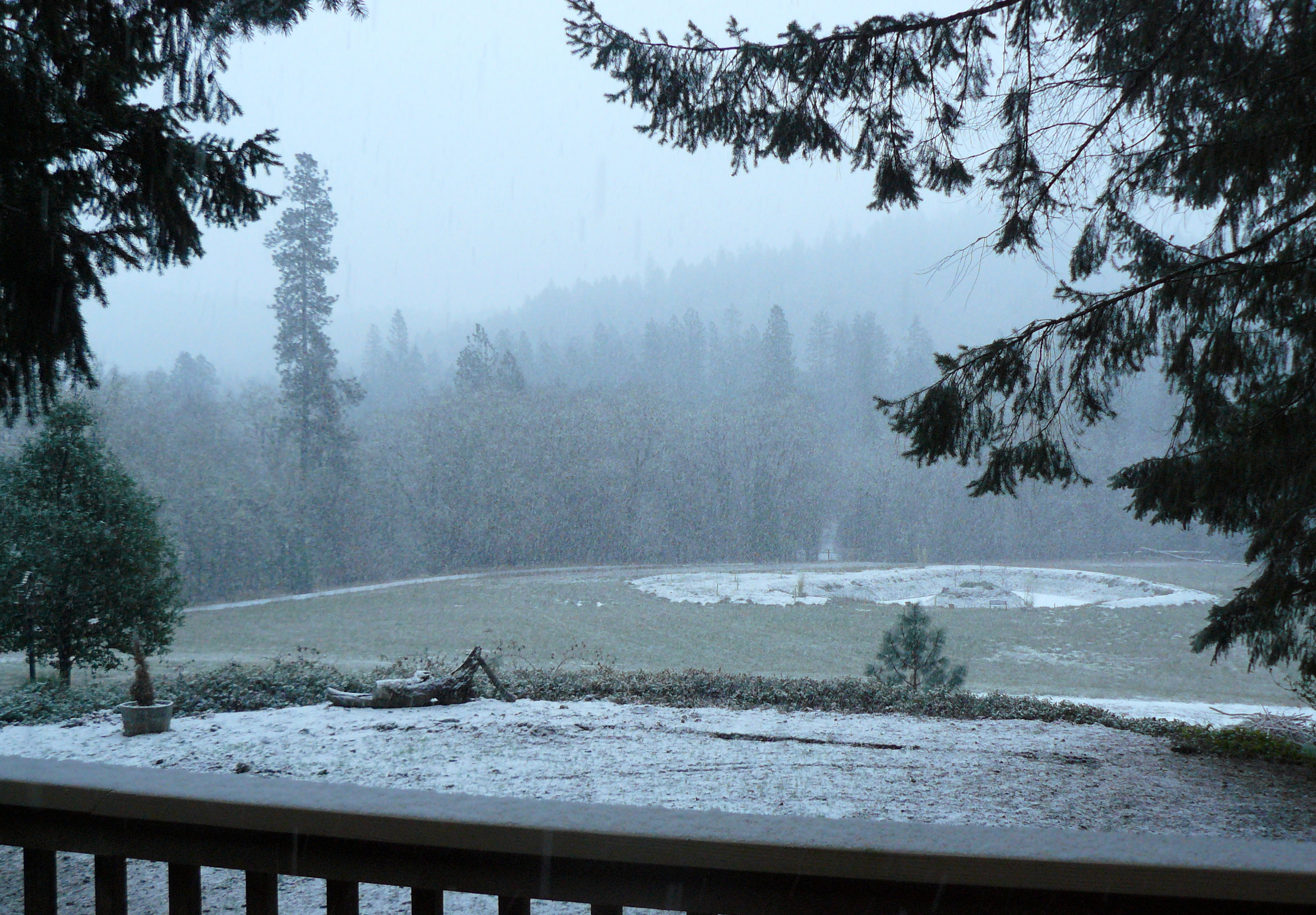
Last Sunday I published a set of pictures from Dan Gomez showing a wonderful collection of clever things you can do with snow. The post closed with a weather warning that Oregon was set to experience some wintery weather before the week was out.
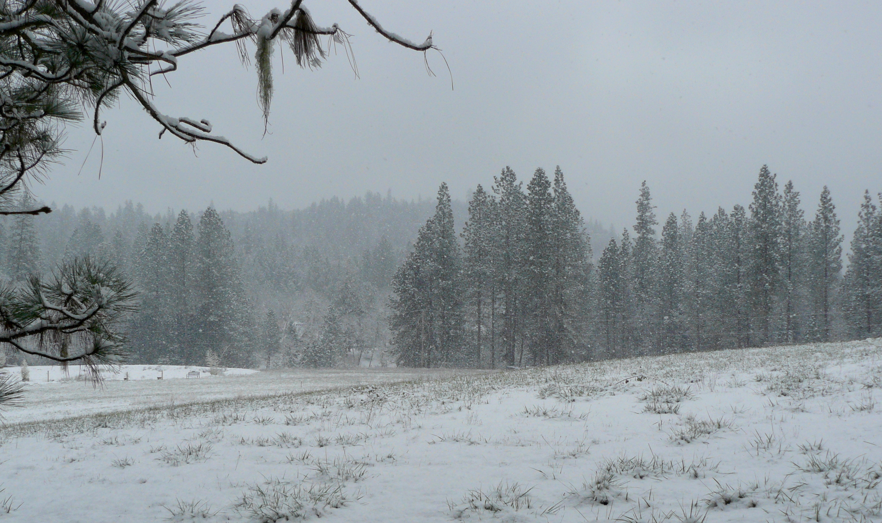
Thus a small collection of photographs taken on our property last Friday afternoon offering proof that the snows did arrive.
Snow just starting. Last Friday around 7am
oooo
Again, taken at 7am.
oooo
Looking down the driveway at 3pm last Friday.
oooo
Looking across to the South-East.
oooo
Nature’s colours.
oooo
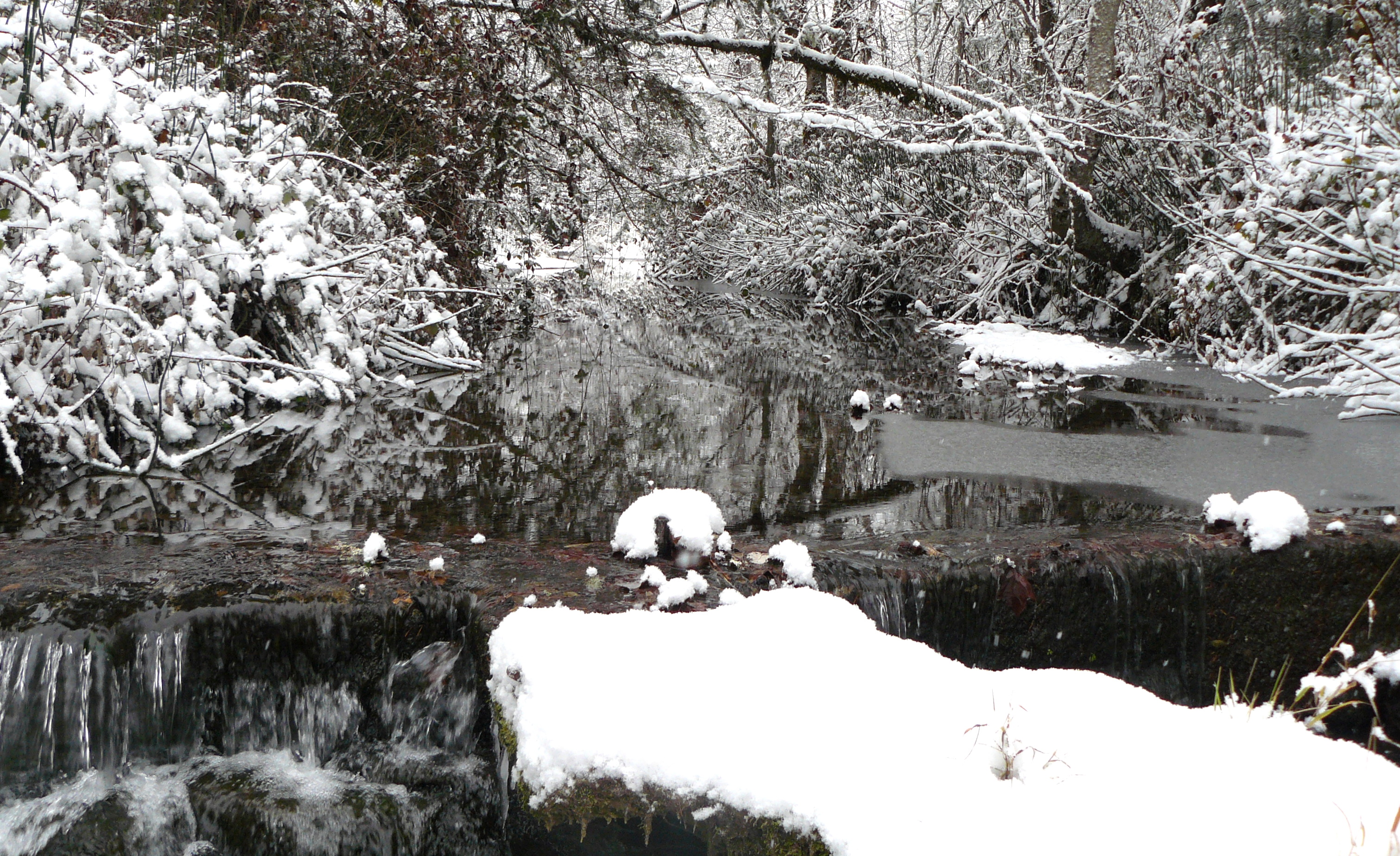
Bummer Creek, looking downstream.
oooo
Bummer Creek, looking upstream from just above the flood irrigation dam.
oooo
Water flowing over the edge of the dam.
oooo
Merry Christmas from the BLM.
Finally, the picture above represents a delightful way to find your Christmas Tree, or Noble Fir in tree speak! We discovered that if one goes to the local office of the Bureau of Land Management (BLM) you can purchase a $5 permit allowing one to go into the forests and cut your own Christmas Tree. The red permit can be seen in the above photograph attached near the top of the tree. So last Thursday we took our Jeep filled to the brim with blankets, spades and tow chains and other paraphernalia to allow us to safely drive some miles into the forest and 2 hours later had our tree.
oooo
Wherever you are in the world, you stay warm and dry this Winter.
Just fancied a change from two days of Democratic Deficit. So today’s post is a brief overview of the US State that Jean and I live in, together with our animals, the State of Oregon.
Now it’s easy to look up a Wikipedia reference to Oregon but what really caught my eye was as a result of a recent visit to the local Grants Pass office of the Bureau of Land Management. We had gone there to purchase a $5 permit that allows us to go on to BLM land and harvest our own Christmas Tree!
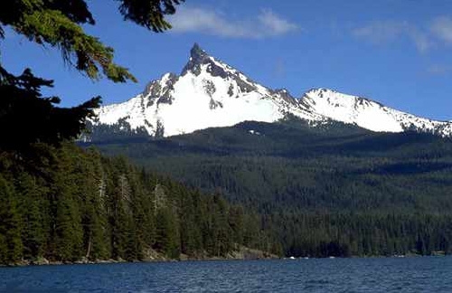
In the Grants Pass office were a number of brochures of scenic attractions in Oregon and we picked up one describing the Rogue-Umpqua National Scenic Byway. Just a quick browse reminded us of Oregon’s stunning and dramatic scenery. Just wanted to share some images.
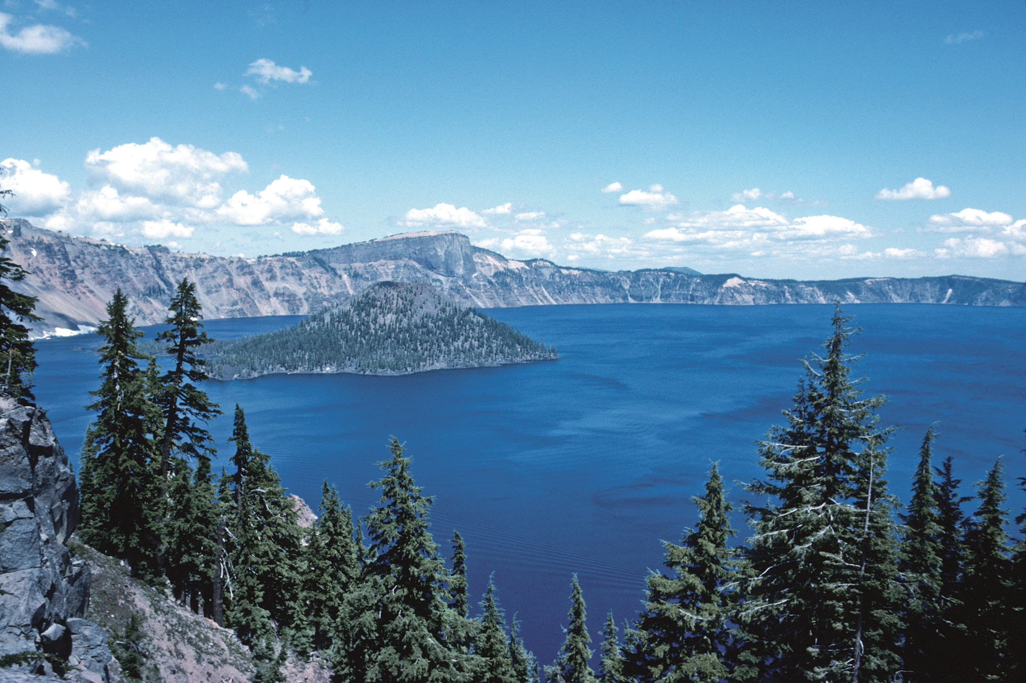
At a depth of 1,932 feet Crater Lake is the deepest lake in the United States. It was formed more than 7,500 years ago when the Mount Mazama volcano erupted and then collapsed back in on itself.
The lake partly fills a nearly 2,148-foot (655 m)-deep caldera[1] that was formed around 7,700 (± 150) years ago[2] by the collapse of the volcano Mount Mazama. Human interaction is traceable back to the indigenousNative Americans witnessing the eruption of Mount Mazama. There are no rivers flowing into or out of the lake; the evaporation is compensated for by rain and snowfall at a rate such that the total amount of water is replaced every 250 years. At 1,943 feet (592 m), the lake is the deepest in the United States, and the seventh[3] or ninth deepest in the world, depending on whether average or maximum depth is measured.[4]
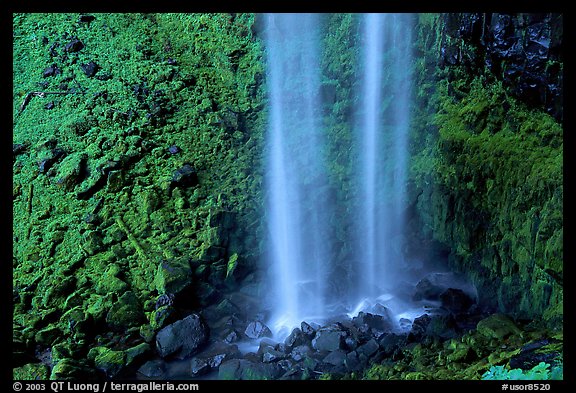
Watson Falls is the third highest waterfall in Oregon at 272 feet. It is the most beautiful waterfall along the North Umpqua River Valley. You will cross a wooden bridge below the falls that will put you right into the lower rapids with an amazing view of the falls as they roar over the basalt lava cliffs ahead.
Someone who goes under the handle of HikingTheWest posted this video on YouTube about 6 weeks ago.
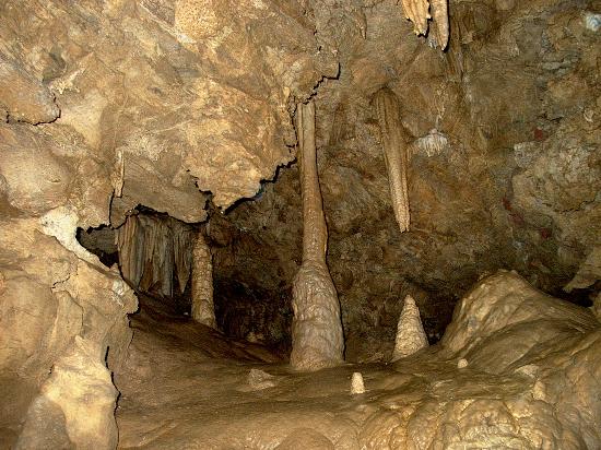
Oregon Caves
These caves are an Oregon National Monument with full details on the US National Park Service’s website. That website explains:
Nestled deep inside the Siskiyou Mountains, the caves formed as rainwater from the ancient forest above dissolved the surrounding marble and created one of the world’s few marble caves. The highly complex geology found on the Monument contributes to the unusual and rare plants and animals found nowhere else but here.
A view of the inside of the caves.
There are many good videos of the Oregon Caves on YouTube so do have a browse if you want to. This one caught my eye, especially as it was filmed in January, 2013..
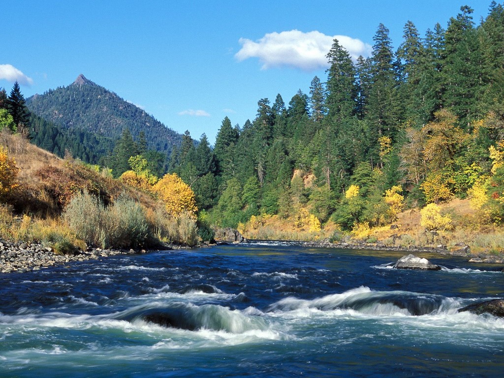
Rogue River
The Rogue River
Final sight for today, the Rogue River runs close by Grants Pass, our nearest town to where we live. Again there is a Wikipedia entry from which one learns that, “Although the Rogue Valley near Medford is partly urban, the average population density of the Rogue watershed is only about five people per square mile (12 per km2).”
Just reflecting on that last paragraph, a simple calculation reveals that the State of Oregon has a population of around 3.9 million people with an land area of 98,300 square miles. Thus the population density of Oregon is 39.6 persons per square mile. To put that into perspective, our neighbouring Californians to the South enjoy a population density of 238 persons per square mile!
Jean and I are very lucky to be living in such a beautiful part of Southern Oregon.
But on this Saturday in November it really is a fish story, or so I thought.
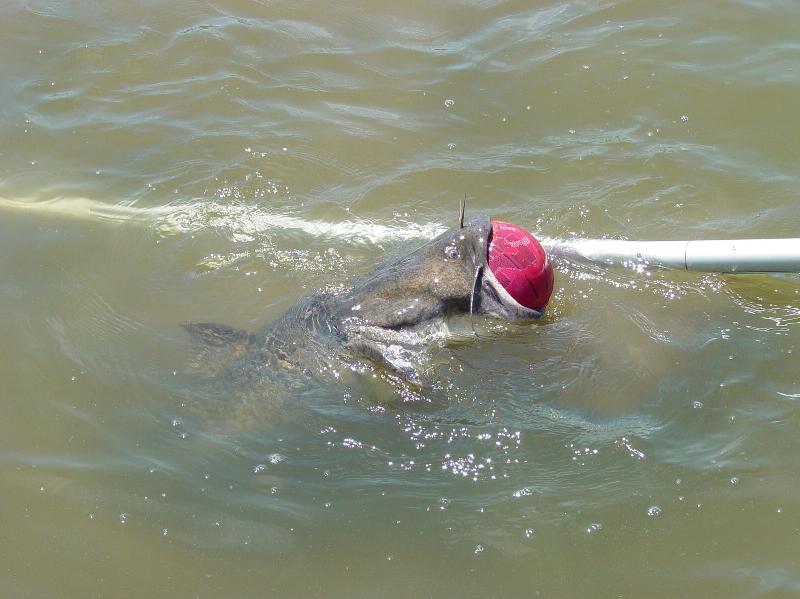
Earlier in the month, I received an e-mail from Dan Gomez. It told of this tale from Grand Lake St. Marys:
A guy who lives at Lake Saint Mary’s (60 miles north of Dayton, OH ) saw a ball bouncing around kind of strange in the lake and went to investigate.
It turned out to be a flathead catfish that had apparently tried to swallow a basketball which became stuck in its mouth!!
The fish was totally exhausted from trying to dive, but unable to, because the ball would always bring him back up to the surface.
The guy tried numerous times to get the ball out, but was unsuccessful. He finally had his wife cut the ball in order to deflate it and release the hungry catfish.
You probably wouldn’t have believed this, if you hadn’t seen the following pictures:
oooo
oooo
oooo
oooo
oooo
Be kinder than necessary because everyone bites off more than they can chew sometime in life…
oooOOOooo
I loved the story but then wanted to know: was it true?
Sadly, the story is true but the location is false. Snopes.com researched this back in 2005. Hoax-Slayer.com wrote about it in 2007 after it “went viral”.
The true story originated in the Whichita (Kansas) Eagle on May 30, 2004. The man in the photo turns out to be Bill Driver, a fisherman at Sandalwood Lake who discovered the catfish with a taste for hardwood glory.
Two wonderful lessons to be learned from both the story and the story behind the story!
Don’t believe everything you read on the Internet and there’s always something fishy about a fisherman’s tale.
As is the way of things, my post yesterday, The growth of empathy, unwittingly set the scene for today’s post. Here’s why!
In yesterday’s post I mentioned Fukushima and the power of blogging in connecting so many all across the world. Maurice Barry, who writes his own blog, left a comment:
Regarding Fukashima I’m still left wondering whether the real problem is the lack of social conscience in the top level leaders or the apathy of ordinary people like you and I who let them carry out their plans.
To which I replied, “Maybe just the power of 20:20 hindsight?”
So to today’s post.
One of the items in yesterday’s Naked Capitalism Links was the headline: Is there a media blackout on the fracking flood disaster in Colorado?That caught my eye and in a moment I had gone across to the blogsite: Bluedaze Drilling Reform.
This is what I read:
Is there a media blackout on the fracking flood disaster in Colorado?
I will update this post as residents send me pictures and video.
We need the national news stations to go cover the environmental disaster that’s happening in Colorado right now.
This picture taken by a resident is from yesterday.
From an email.
I see you’ve noticed the underwater wells in Weld County, Colorado. Amazing; we’ve emailed the Denver TV stations, other media, and state and local politicians. We’ve sent pictures that our members have taken. It’s like the media and politicians have been TOLD not to say anything about it. There has been no mention of the gas wells on the Denver newscasts either last night or this evening although all stations have had extensive and extended flood coverage. You can see underwater wells in the background of some of the newscast videos, and yet the reporters say absolutely nothing.
Here’s a picture one of our members took yesterday in Weld County, Colorado. We’ve got tons more on our website. Check it out. The tanks are tipping and, in some cases, have fallen over. They have to be leaking toxins into the flood waters. There have to be hundreds if not thousands of underwater well pads in Weld County as a result of the flooding.
Please publicize this in Texas since our media people and politicians have gone silent!
The reason I called today’s post ‘Questions without answers’ was because there are so many complex issues today. So many issues that cannot be understood in simple ‘question and answer’ ways. But one hope of finding answers to the complex questions of these times is through the sharing, caring ways of communicating that so many can access. No more passionately demonstrated than by TXSharon in her About section of her blog.
Finally, I shall leave you with another great dog picture from Chris Snuggs. So beautifully appropriate to the complex world we live in.
Can’t recall how, but recently I came across a wonderful collection of photographs of waterfalls presented by MNN – Mother Nature Network. There are 16 photographs; I took the liberty of sharing just a few of them with you today.
Dettifoss
Located in Northeast Iceland, the massive Dettifoss is generally recognized as the largest and most powerful waterfall in Europe. It is protected within the Vatnajökull National Park and remains untapped as an energy source. Plans to build a hydroelectric plant at the site have proven to be an engineering risk.
Gocta Cataracts
Well-known to locals for centuries, this towering waterfall remained a secret from the rest of the world until as recently as 2005, when German explorer Stefan Ziemendorff became the first outsider to witness it. Located in a remote Amazonian province in Peru, the Gocta Cataracts is one of the world’s tallest waterfalls. Though accurate measurements of its height have yet to be taken, an initial estimate placed it as the third highest in the world.
Locals kept the location secret because they feared that revealing its whereabouts would release the curse of a beautiful blond mermaid who is rumored to live in the waters.
Havasu Falls
Plunging over majestic red rocks and pooling into milky, turquoise water, it’s easy to see why Havasu Falls is one of the most photographed waterfalls in the world. It helps that the location is deep within breathtaking Grand Canyon National Park, where the waters eventually converge with the mighty Colorado River.
Kaieteur Falls
Located in Guyana’s Kaieteur National Park, this waterfall is reputed to pour more water over a great height than any other waterfall in the world. According to the World Waterfalls Database, Kaieteur Falls is the world’s 123rd tallest (single and multi-drop waterfall) and the 19th largest waterfall in terms of volume. In other words, this site has a rare combination of height and water volume, which helps to quantify its spectacular beauty.
Niagara Falls
The most powerful and most famous waterfall in North America, Niagara Falls pours more than 6 million cubic feet of water over its crest line every minute during high flow. Located on the border between the state of New York and the province of Ontario, Canada, the falls are an important source of hydroelectric power for both countries. The site has inspired its share of daredevils who have attempted to plummet over the falls in barrels, or who have tiptoed over them on a high wire.
Nature’s Power
Few natural wonders encapsulate the sublime power and impermanence of the wild better than roaring waterfalls. The force of a waterfall can carve a valley out of mountains, shape the world’s grandest canyons and even power our electrical grids.
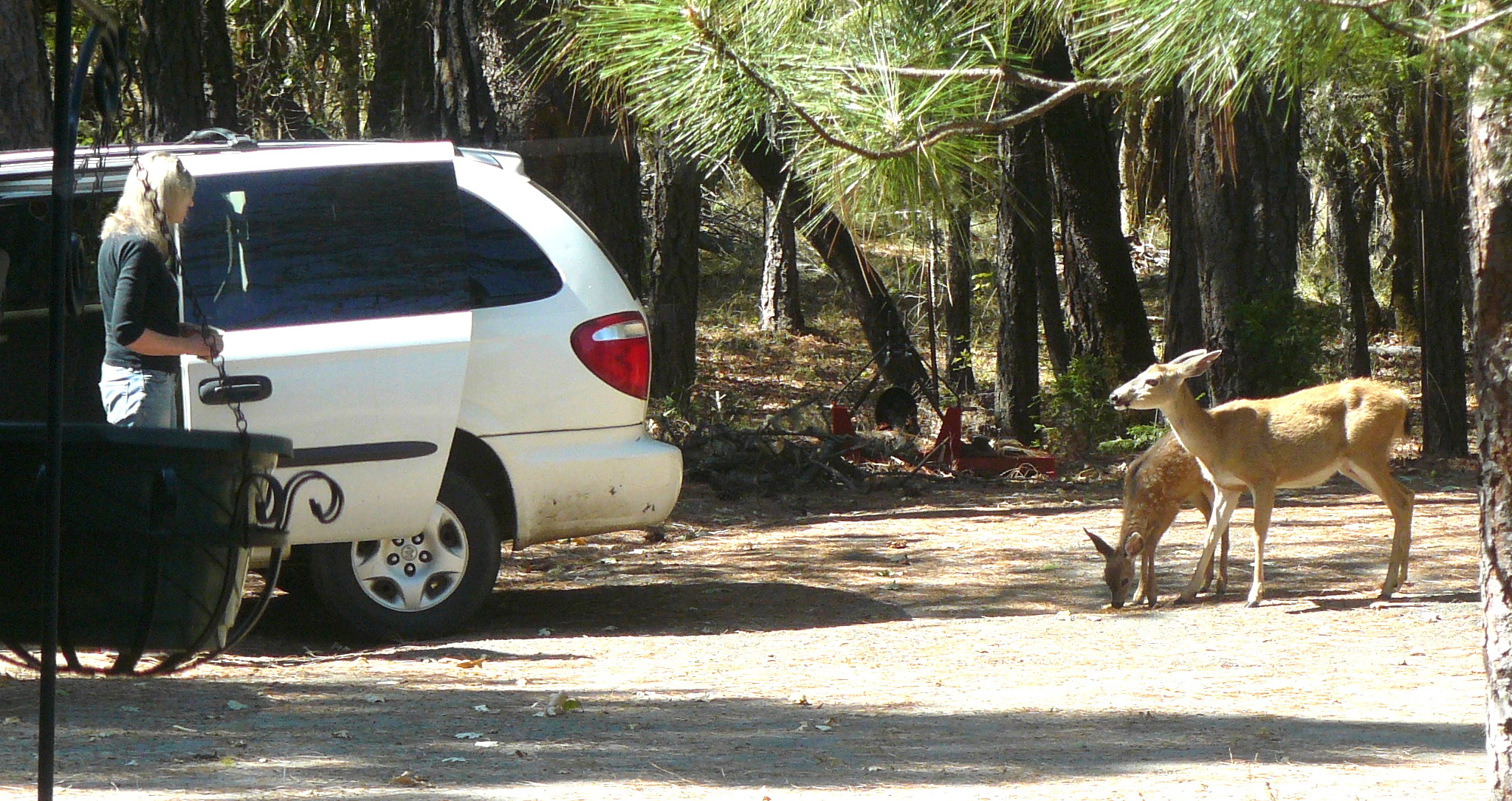
Here are two photographs taken on Friday when a mother deer and her young fawn overcame shyness of Jean in order to feed on some grains that Jean had placed near her car.
Trust between deer and Jean.
Later the young fawn was nibbling the grass in front of the tractor, allowing the following picture to be taken.
Magical moment.
We sincerely hope we can set up some regular pattern of feeding the deer, especially during the coming Winter.