Tag: University 0f Colorado Boulder

The wildfire smoke

A useful article from The Conversation.

When I first read this article, I thought everyone will be aware, such is the awareness of wildfire smoke in so many places, and media.

Then I realised that this was wrong, and if only one or two people benefit from the advice then it should be republished. The original was on The Conversation.

ooOOoo

Yes, breathing wildfire smoke can harm your health – here’s what you can do to protect yourself
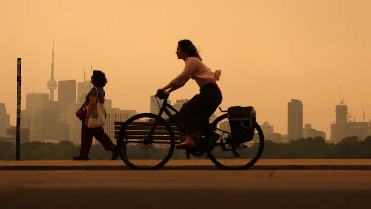
A woman rides a bike through city air tinted orange by wildfire smoke. Neither she nor a woman walking in the background is wearing a protective mask.
Heavy wildfire smoke from Canada’s forests turn skies orange in Toronto and across parts of the U.S. in July 2026. Steve Russell/Toronto Star via Getty Images

Colleen E. Reid, University of Colorado Boulder

Wildfire smoke from fires burning in Canada and northern Minnesota has been pouring across the Great Lakes and northeastern U.S. states, turning skies an eerie shade of orange. In the West, smoke has also been spreading into communities in Colorado and neighboring states as more wildfires burn in hot, dry conditions in July 2026.

University of Colorado environmental health researcher Colleen Reid explains what’s in that smoke and why breathing it is a health concern everyone should be aware of.

What is in wildfire smoke?

Wildfire smoke is a complex mixture that includes nitrogen oxides, volatile organic compounds, polycyclic aromatic hydrocarbons, carbon monoxide, carbon dioxide and particulate matter. When homes or buildings also burn, they can release an even more toxic stew of chemicals from burning electronics, furniture, plastics, paints and much more.

What you see when you see a smoke plume or when the air is hazy with wildfire smoke are the tiny particles that are too small to fall to the ground right away with gravity.

These particles, which scientists call particulate matter, are very small – we measure them in microns. When you breathe them in, they can harm your health. The smaller the particles, the deeper they can get into your lungs and body.

Map shows heavy smoke and low air quality across the Great Lakes Region and into the Northeast
EPA air quality monitors show high risks from smoke in many parts of the Great Lakes and northeastern U.S. on July 15, 2026. Reds are considered very unhealthy levels. Purples are either extremely unhealthy for light purple or hazardous for areas in maroon. AirNow Fire and Smoke Map

You may have heard the term PM2.5. It means particles that are 2.5 microns or smaller in diameter, many times smaller than the width of a human hair. High concentrations of these particles in the air during wildfire smoke episodes are what trigger air quality alerts.

Has wildfire smoke been increasing recently, and why?

Yes, wildfires have become more frequent and more intense just in the past couple of decades, and when wildfires become more frequent and intense, so does the smoke.

Scientists have found that wildfires are becoming more frequent due to a variety of factors that include increases in fire weather – hot, dry, windy conditions that fuel the spread of fires due to climate change – as well as other natural and human factors. The reasons for the increases in wildfires vary in different parts of the world.

Other studies have found that wildfire smoke makes up an increasing portion of the PM2.5 in the air in the U.S., and in many areas it is offsetting the decreases in air pollution that the U.S. has gained through regulations of industrial and vehicle emissions under the Clean Air Act.

How could wildfire smoke affect my health?

Some effects of breathing wildfire smoke include shortness of breath, coughing, itchy or watery eyes, headaches, rashes and itchiness. But smoke can cause more serious harm. Numerous epidemiological studies have shown that hospitalizations and emergency department visits for asthma and other respiratory diseases increase during wildfire smoke events.

After you breathe in the particles, they cause inflammation and oxidative stress, and they can move into the blood and spread throughout the body, affecting other organ systems.

People stand in a field as a smoke plume turns the sky orange and then dark.
The height of a smoke plume, like this one from Colorado’s Aspen Acres fire near Pueblo on July 1, 2026, affects the amount of particles and chemicals people on the ground are exposed to. But generally, if you can smell smoke, you’re breathing it in. Michael Ciaglo/Getty Images

Breathing wildfire smoke has been associated with higher risk of preterm births and other issues during pregnancy, and potentially cardiovascular problems such as heart attacks and strokes, although the evidence for these effects are more mixed.

The longer-term health effects of wildfire smoke are less clear, but it is a growing area of research.

Where can I learn more about wildfire smoke risks where I live?

The first thing to do to protect yourself from wildfire smoke is to know how bad the smoke is and how long it is going to last.

One great place to get information for where you live on current wildfire smoke is fire.airnow.gov. You can zoom in on the map to where you live and find color-coded circles reflecting data from both U.S. EPA air-quality monitors and PurpleAir sensors that people have put in their homes.

The colors show the level of PM2.5 at that location and suggest the associated health risk.

To find out how wildfire smoke is expected to change over time in North America, you can look at maps from FireSmoke Canada and the U.S. Interagency Wildland Fire Air Quality Response Program.

What can I do to protect myself and my family from wildfire smoke?

First of all, depending on the level of the air quality index where you are, there are different recommendations. When wildfire smoke reaches unhealthy levels, stay indoors as much as possible, with doors and windows shut to keep the wildfire smoke out.

If you have an air cleaner, use it, but check the filter, as filters can fill up quickly. Similarly, check the filter on your home HVAC system and replace it if needed.

If you have to go outside, consider wearing a well-fitting N95, KN95 or KF94 mask. These masks can protect you from inhaling particles in the air around you. Looser masks, such as surgical masks, mostly protect others from what you breathe out instead. They do not have a tight seal around your mouth, and when you breathe in, the air with all of the particles can find its way around the sides of the mask.

Having a tight fit of the mask to your face is important so that when you breathe, the air is going through the mask and capturing the smoke particles rather than letting them into your body where they cause harm.

If your home is leaky and you can see haze inside, consider going to a public space, such as a library or mall, with a good HVAC system. Some municipalities have designated clean air spaces where anyone can go.

Colleen E. Reid, Associate Professor of Geography, University of Colorado Boulder

This article is republished from The Conversation under a Creative Commons license. Read the original article.

ooOOoo

Thank you, Colleen, and thank you The Conversation. Lots of good advice.

Our changing world.

Now, it is the technology being applied to our electricity supply.

Although we have an array of solar panels here at home, we still have electricity cables coming to the house. In the Winter, when the solar panels are nowhere enough for our electic consumption, we depend on Pacific Power to provide the electic power for our home.

That is why the following article, published by The Conversation, was highly relevant.

ooOOoo

Electric companies don’t need to black out customers to prevent wildfires – here are 3 relatively fast, affordable solutions

Jasmine Garland, University of Colorado Boulder

A severe winter snow drought has left snowpack levels far below normal across the American West in 2026. Without a slow-melting blanket of snow to keep the soil and forests moist, alpine vegetation is drying into a tinderbox earlier than normal and ramping up the fire risk.

The historic dryness means electric utilities are facing a dilemma: how to deliver power through dry, windy regions without accidentally starting a catastrophic fire.

To cope, many utilities are turning to a controversial method pioneered in California: the public safety power shut-off – better known as a preemptive blackout. Imagine your power provider deliberately cutting electricity to your entire neighborhood for hours to days, not because a storm hit or a wire broke, but because the weather forecast is hot, dry and windy. This preventive darkness is fast becoming the new normal for millions of residents in the West.

A map of the Western U.S. shows just about everywhere except northern Idaho far below normal.
Most of the snowpack in the Western U.S. was far below the 30-year average in June 2026, suggesting a dry summer ahead. Snow-water equivalent is a measure of the amount of water in snowpack. National Water and Climate Center

As an energy systems researcher living in the West, I study how our electric grid interacts with these escalating climate risks. I believe utilities have better options that boost fire safety quickly while avoiding the drastic move of shutting off the power or investing in expensive alternatives, such as underground power lines or microgrids.

Billion-dollar spark: Why the West is going dark

To understand why a utility would willingly turn off its own product, you have to look at how the Western grid was built.

Most rural power lines consist of bare, uninsulated aluminum wires strung across thousands of miles of wooden poles, often through rugged forests. If those wires accidentally touch one another or trees or the ground, they can short-circuit, sending off sparks that can start fires.

This system, once considered the greatest engineering achievement of the 20th century, has been responsible for some of the worst fire disasters in U.S. history.

Utility workers in hard hats and reflective vests burying a power line in a trench next to a road.
Burying power lines can keep the wind from blowing tree branches into them, but it can be prohibitively expensive, particularly where transmission lines pass through rugged mountains. AP Photo/Rich Pedroncelli

In California, electricity infrastructure has ignited eight of the state’s 20 most destructive wildfires. The legal and financial fallout can be devastating. In 2019, Pacific Gas & Electric was forced into bankruptcy due to an estimated US$30 billion in wildfire liabilities stemming from equipment-caused blazes, including the 2018 Camp Fire that destroyed much of the town of Paradise. Because utilities are regulated monopolies, they can pass these massive liability costs to their customers over time.

California utilities have been using preemptive outages for several years to avoid causing more fires on hot, dry, windy days. Today, that strategy has spread beyond the state. According to the Western Electricity Coordinating Council, the independent grid reliability authority for the West, 24 western power entities had used preemptive shut-offs by 2026.

Colorado’s Xcel Energy implemented its first major preemptive blackout in 2025. Some of these outages have left communities without power for up to five days.

Chart shows how the number of utilities and agencies with policies for preemptive blackouts increased from 16 in the years before 2025 to 24 in 2026 alone
The number of utilities and agencies with policies of using wildfire preemptive blackouts has risen quickly in recent years in Western states. Jasmine Garland, based on WECC data, CC BY-ND

Fortunately, keeping communities safe does not have to mean leaving them in the dark. There are ways utilities can modernize electric system infrastructure quickly that lower the fire risk and keep the power flowing.

Solution 1: Covered conductors

The quickest, most cost-effective physical fix is to use covered conductors. Think of the electrical cords in your house. If you touched the bare copper wire inside, it would spark. But you don’t get shocked by household cords because they are wrapped in plastic insulation.

Utilities like Southern California Edison are actively wrapping their high-risk mountain wires in heavy, weather-resistant polymer insulation. By the end of 2025, SCE had installed over 700 circuit miles (1,126 kilometers) of this insulated “tree wire” in high-fire districts over the span of about a year and committed to modify an additional 1,481 miles (2,383 kilometers) by 2028.

A worker stands by a giant roll of covered conductor line – power lines covered in a plastic.
A Southern California Edison crew installs new covered conductor power lines in Aguanga, Calif. Elisa Ferrari/Southern California Edison

If a severe windstorm blows a heavy pine branch directly onto an insulated line, it simply rests against the wire without sparking. It is a highly effective middle-ground fix that’s significantly less expensive than burying transmission lines in mountain forests, and it can be deployed rapidly across thousands of miles.

2. ‘Fast-trip’ settings and topology optimization

Another option is to change how the electricity behaves inside the power line using automated technology.

Traditionally, if a tree branch touched a power line, the system would try to push electricity through the line anyway, causing repeated sparking. Today, utilities are deploying “fast-trip” settings on their circuit breakers.

Think of these like the ultra-sensitive circuit breakers in your home. The microsecond a branch bumps an outdoor line, these smart systems detect the disruption and cut the power to that specific wire before a spark can even form. This allows operators to isolate a single high-risk area rather than shutting down power to an entire county.

Topology optimization is another promising operations technique. It acts like Google Maps for the electric grid. Instead of shutting power down when one line is facing high risks, advanced software attempts to safely route electricity around the danger zone using neighboring, lower-risk lines.

By dynamically changing the pathway of the power, utilities can drastically reduce the electrical load and heat on vulnerable lines without cutting power.

Solution 3: AI and real-time smart sensors

Advanced computer software and artificial intelligence are also helping utilities act with surgical precision.

In the past, if a utility feared a windstorm could spark a fire, it had to shut off power to a large region because it lacked localized data. Today, utilities are deploying smart sensors called dynamic line rating that are installed directly onto power lines. These sensors act like digital stethoscopes, measuring real-time wire temperature, wind speed and line sag.

When combined with panoramic, AI-powered camera networks, the grid gains eyes. Xcel Energy in Colorado has deployed 81 of these cameras. Instead of executing a sweeping blackout, operators can use these cameras and automated smart switches to isolate the high-risk span in a windy canyon while keeping the lights safely on for the surrounding town.

The era of risk-aware grid design

The future of Western energy relies on moving away from static, 20th-century safety manuals and toward a practice called risk-aware dispatching.

In simple terms, this means treating the power grid like a living, breathing weather map. On a calm day, electricity is routed along the cheapest path. But when fire conditions spike, AI algorithms will automatically recalculate the region’s electricity flow, diverting power away from fragile forest lines and routing it through safer plains or underground urban corridors.

The era of cheap, unmonitored overhead power lines is over. To adapt to a changing climate, I believe the grid must evolve from a passive network of copper, aluminum and wood into a smart, dynamic machine. By combining insulated wires, targeted undergrounding of power lines, and real-time sensor data, utilities can avoid sparking devastating fires without resorting to frequent blackouts.

Jasmine Garland, Ph.D. Candidate, University of Colorado Boulder

This article is republished from The Conversation under a Creative Commons license. Read the original article.

ooOOoo

We live (very happily) in a rural part of Southern Oregon. Much of the land close to us is covered in trees. Large parts of our property has trees and bushes. We try and keep the area directly around the home clear, but what with me being over 80 and Jeannie with Parkinson’s, it is a challenging task.

We have had far less snow over the Winter than normal. There is no guarantee the coming Winter will provide the (historically) past levels of snow. We will have to wait and see.

This Winter

The low snowpack this last Winter is concerning.

Although here in Southern Oregon at present we have a few wet days, in general the amount of rain coming down is well below normal levels.

That is why this recent article presented by The Conversation is being published.

ooOOoo

Winter’s alarmingly low snowpack offers a glimpse of the changing rhythm of water in the western US

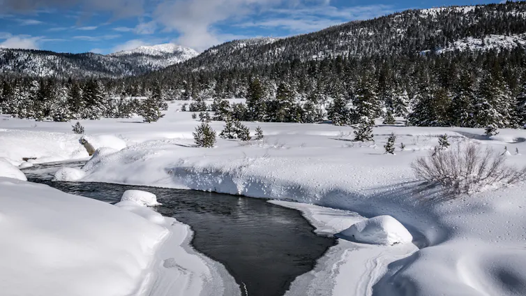
In a good year, the West’s mountain snowpack feeds streams and rivers well into summer. George Rose/Contributor/Getty Images News

Imtiaz Rangwala, University of Colorado Boulder

Winter is more than just a season in the western U.S. – it is a savings account to get farms and homes through the long, dry summer ahead. As the snowpack that accumulates in the mountains through winter slowly melts in late spring and summer, it feeds into rivers and reservoirs that keep communities and ecosystems functioning.

The April 1 snowpack measurement has long been the single most important number in western water management, considered a strong proxy for how much water the mountains are holding in reserve.

But in 2026, that savings account has been woefully deficient.

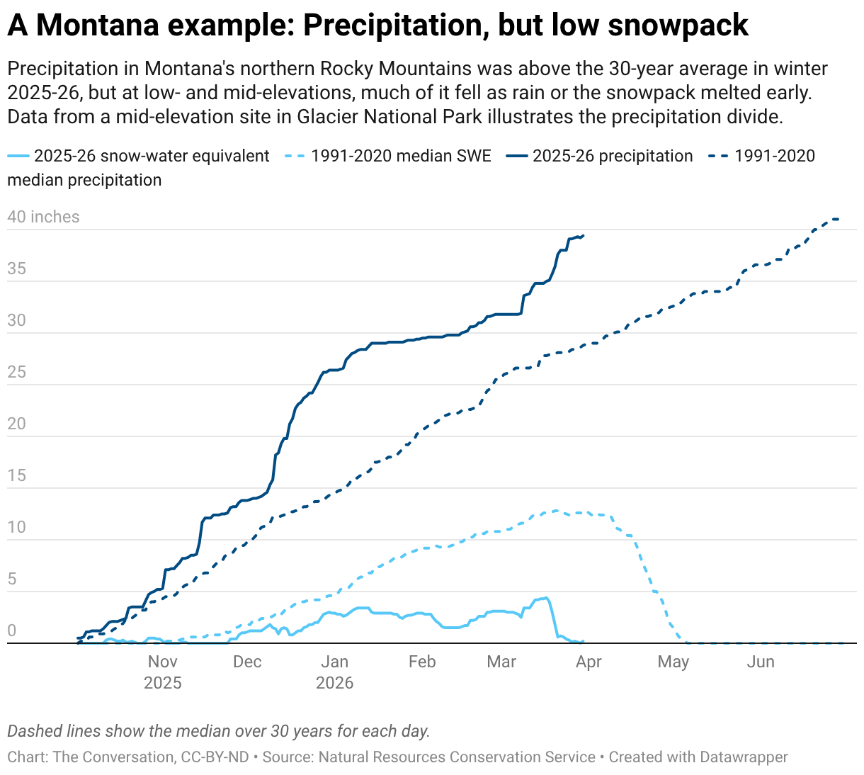
Across the western United States, temperatures from November through February were among the warmest on record, with many areas 5 to 10 degrees Fahrenheit (2.8 to 5.5 degrees Celsius) above the 20th-century average. March continued to break heat records. At lower elevations, the higher temperatures meant a significant part of the winter’s precipitation fell as rain rather than snow. In some places, snowfall accumulated but melted quickly during warm periods.

A chart shows an unusually low amount of area in the West with snow cover during winter 2026.
The total area of the western U.S. with snow cover was exceptionally low compared with the rest of the 21st century. National Snow and Ice Data Center

As a result, even regions that received near- or above-normal precipitation for the season failed to build substantial snowpack. In the northern Rockies and the mountains of the Pacific Northwest, any above-average snow accumulation was largely confined to the highest elevations, while middle and lower elevations had relatively little snowpack.

This situation is a hallmark of warming winters. As global temperatures rise, the freezing line where precipitation changes from rain to snow moves up the mountains, shrinking the area capable of sustaining a seasonal snowpack.

A map shows most of the stations across the western mountains were below 50% of average. The best conditions were in the northern Rockies and Pacific Northwest, and most of those were still below average.
At the vast majority of the U.S. Natural Resources Conservation Service’s snow measurement stations across the West, the snowpack’s snow-water equivalent on March 30, 2026, was less than 50% of the 1991-2020 median. Natural Resources Conservation Service
A map shows wide temperature anomalies in the western U.S. compared with the 20th-century average.
Temperatures were well above the 20th-century average across the western U.S. in winter 2025-26. National Centers for Environmental Information

The exceptionally warm winter of 2025–26 across much of the western U.S. delivered a powerful preview of what the regional water cycle in a warmer climate may increasingly look like: less snow and a fundamental reshaping of the hydrograph – the chart of how much water flows through streams across the year.

A flattening hydrologic pulse

The consequences of this shift for water supplies are already visible in streamflows.

In multiple river basins in the West, streamflows were above average in winter and early spring, and some locations were approaching record-high levels. Historically, that water would have remained frozen in the snowpack until late spring. Instead, precipitation arriving as rain – along with intermittent midwinter melting events – increased the runoff.

Scientists who study natural water flows, as I do, pay attention to the hydrographs of streamflows in river basins to see when the water flow in mountain streams is strongest and how long that flow is likely to continue into summer.

A chart shows a typical arc of increasing water flows as snow melt in 2025, compared with several peaks of snowmelt and rainfall during 2026.
This hydrograph showing two years of water flows in the St. Mary River near Babb, Mont., reflects the difference between a typical late-spring peak, as 2025 saw, and several midwinter peaks from warm temperatures and rain, as 2026 is seeing. U.S. Geological Survey

In recent years, rising temperatures have led to a redistribution of streamflows throughout the winter and early spring in ways that are fundamentally reshaping the hydrographs of snowmelt-dominated rivers. Rather than a single dominant peak during late spring or early summer, smaller peaks emerge in winter and early spring. At the same time, the traditional snowmelt pulse, relied on to fill reservoirs in late spring, weakens.

In effect, the hydrograph is flattening. The winter of 2025–26 illustrates this phenomenon: Higher early-season streamflows suggest the West will see less runoff later in the year when communities, farms and wildlife need it.

The Colorado River: A system on the edge

Nowhere does the convergence of record warmth, depleted snowpack and altered hydrology carry higher stakes than in the Colorado River Basin. More than 40 million people in seven states plus Mexico and 5.5 million acres of farmland depend on the river’s water, but the river’s flow is no longer meeting demand.

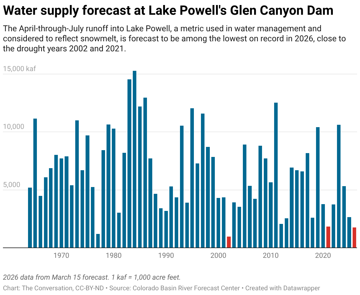
The April-through-July 2026 runoff into Lake Powell – the reservoir behind Glen Canyon Dam and the primary index of the Upper Colorado River Basin’s annual water budget – is currently forecast to rank among the lowest in recent decades. It has been tracking close to the grim years of 2002 and 2021, considered benchmarks of western drought.

Unless spring brings substantial late-season snowfall to the high mountains, 2026 could join those years as a marker of how thin the margin between water supply and demand has become in a river system already under sustained stress from two decades of drought and water overuse.

The low reservoir levels in the basin in 2026 and the low snowpack are adding fears of water shortages just as the seven states that rely on the Colorado River are struggling to reach a new water use agreement.

The changing rhythm of water in the West

The winter of 2025–26 highlights two emerging realities.

First, temperature is increasingly dominating precipitation in determining western water supplies. Even above-normal precipitation cannot compensate for persistent warmth when it falls as rain rather than snow and accelerates snowmelt in the mountains.

Second, the nature of the West’s streamflows is shifting in ways that complicate water management.

Rain-on-snow events can produce flooding in winter, as the Seattle area saw in late December 2025. A low snowpack also means less runoff in summer, which can exacerbate water shortages and raise the wildfire risk as landscapes dry out. Even if a year has normal precipitation, if it falls as rain or there is earlier snowmelt, then evaporation through summer, in a warmer climate, will leave less water in the system.

Snowpack declines, earlier runoff, elevated winter flows and flattened hydrographs are all consistent with long-standing projections for the western United States as global temperatures rise.

What makes the winter of 2025-26 notable is how clearly these signals appeared, even in a year without widespread precipitation deficits.

This shift highlights the need for adaptive reservoir operations – the ability to adjust water storage and release decisions in real time to capture earlier runoff and preserve water for longer dry seasons, while still maintaining space in reservoirs for flood control during wetter winters. For communities across the West, it also reinforces the growing reality that the familiar seasonal rhythm of mountain water is changing.

Imtiaz Rangwala, Senior Research Scientist in Climate, Cooperative Institute for Research in Environmental Sciences, University of Colorado Boulder

This article is republished from The Conversation under a Creative Commons license. Read the original article.

ooOOoo

There is nothing we citizens in the West can do about this, apart from being careful about the water we use.

As Imtiaz Randwala wrote in the last paragraph in the above article: “This shift highlights the need to adaptive reservoir operations.