In the past, studies have disagreed on whether forests with lower or higher canopies will be more likely to make it through prolonged spells of hot, dry weather. The discrepancy has made it difficult for forest managers, who need to know which tree heights to encourage to ensure the highest growth and survival rates during extreme drought.
Study leader Peipei Xu at Beijing Normal University in China and her colleagues believe the issue is increasingly pressing. “Climate data indicate that warm areas of land are increasing, and the warmed areas are also drying,” says Chuixiang Yi at the City University of New York, US. “Hot-dry-induced forest mortality poses a significant global concern for the future as carbon dioxide continues to rise and the climate continues to warm.”
Xu, Yi and the rest of the team aimed to quantify the relationships between canopy height, growth and survival rates during drought accurately for the first time. They analysed data gathered during a severe drought in the southwestern US in 2002 that showed the effect on the ring widths of tree trunks, a useful indicator of their yearly growth. In addition, satellite data revealed how the density of vegetation changed over the course of the drought; the team used this to calculate both leaf growth and tree mortality rates.
The results revealed that trunk and leaf growth under drought conditions increased with canopy height for trees shorter than 18 metres but decreased with height for trees taller than 18 metres. “Our results indicate that both high and small trees have relatively low drought resistance,” says Yi.
After establishing these relationships, the researchers could determine the biological mechanisms governing tree growth and survival during drought.
“All organic matter in a tree is formed on the leaves at the top of the tree by photosynthesis,” Yi explains. “Tall trees have a longer water transport path from roots to leaves and [it’s] more difficult to overcome tissue resistance and … gravity, particularly under dry conditions. The roots of small trees are short, and their abilities to access water and nutrient supplies unavailable to the surface soil layer are extremely limited.”
The researchers believe that using their results to inform the active management of canopy structure could safeguard vulnerable forests. As climate models predict hotter, drier droughts becoming more commonplace, this could be essential to combat forest dieback – a phenomenon that will also drive climate change.
“Our findings provide insights into how to manage forests or plant what trees to increase forest drought resistance in facing hot-dry climate conditions to mitigate climate change,” says Yi.
This came in yesterday and is shared with you as per normal.
Steve’s Real Food Recalls Dog and Cat Foods
September 7, 2018 — Steve’s Real Food of Salt Lake City, Utah is voluntarily recalling limited quantities of its raw frozen dog and cat foods due to possible contamination with Salmonella and Listeria bacteria.
What’s Recalled?
The affected products were nationally distributed and are identified with the following UPC codes and “Best by” dates located on the front of the bag.
Steve’s Real Food Turducken Recipe
Package size: 5-pounds
Lot number: J155
Best By Date: 6/4/19
UPC: 6-91730-15304-5
Quest Emu Diet
Package size: 2-pounds
Lot number: B138
Best By Date: 5/18/19
UPC: 6-91730-17103-2
Quest Beef Diet
Package size: 2-pounds
Lot number: A138
Best By Date: 5/18/19
UPC: 6-91730-17101-8
About Salmonella and Listeria
Salmonella and L. mono can affect animals eating the products and there is risk to humans from handling contaminated pet products.
Symptoms of infection in people include nausea, vomiting, diarrhea or bloody diarrhea, abdominal cramping and fever.
Consumers exhibiting these signs after having contact with this product should contact their healthcare providers.
Pets with Salmonella and/or L. mono infections may be lethargic and have diarrhea or bloody diarrhea, fever, and vomiting.
Some pets will have only decreased appetite, fever and abdominal pain.
Infected, but otherwise healthy pets can be carriers and infect other animals or humans.
If your pet has consumed the recalled product and has these symptoms, please contact your veterinarian.
What Caused the Recall?
This recall is being initiated after the firm was notified by the Washington Department of Agriculture when sample was collected and tested positive for Salmonella and/or Listeria.
The firm did conduct its own test which produced a negative result for both Salmonella and Listeria monocytogenes.
However, because of the company’s commitment to overall safety and quality, Steve’s Real Food is conducting a voluntary recall of these products.
Consumers should also follow the safe handling tips published on the Steve’s Real Food packaging, when disposing of the affected product.
No pet or human illnesses from this product have been reported to date.
This recall is being made with the knowledge of the U.S. Food and Drug Administration.
What to Do?
Consumers are encouraged to check the lot code and best buy date of the affected pet foods.
Any product with the noted lot code and best buy dates should be returned to the specialty retailer where product was purchased for a full refund.
Consumers with questions may contact Steve’s Real Food at 888-526-1900, Monday through Friday, 9 am to 4 pm MT.
U.S. citizens can report complaints about FDA-regulated pet food products by calling the consumer complaint coordinator in your area.
Jeannie and me reacting to the last report on the Oregon Department of Forestry (ODF) Southwest website:
Hugo Road Fire FINAL Update 09/06/18
Quick Facts:
Incident Start Date: 09/02/2018
Incident Start Time: Approx. 7:15 p.m.
Incident Type: Wildfire
Cause: Under Investigation
Incident Location: Hugo, which is roughly ten miles north-northwest of Grants Pass in Josephine County, Oregon
Land Threat: Private
Command Agency: ODF
Fire Size: 199 acres
Containment: 86%
Current Situation:This will be the final update for the Hugo Road Fire unless conditions significantly change.
Firefighters continue to boost containment on the Hugo Road Fire, now reaching 86 percent. The fire remains at 199 acres.
Overnight, crews were able to mop up 300 feet from the fire’s edge, adjacent to roadways, and surrounding the perimeter of homes. Within the mop up area, very few hot spots were found. All residences are at a Level 1 “Be Ready” evacuation notice, and will remain at such until Fire Season 2018 comes to a close, per the Josephine County Sheriff’s Office.
Local fire personnel will continue gridding the landscape for interior hot spots and conducting suppression repair throughout the next few days. It is normal to see light smoke during this process, but it is now well within the interior of the fire’s footprint which does not pose a threat to our community. There will still be fire apparatus present until the final mop up stages are complete. We encourage everyone to continue to use caution while traveling through the area.
Thank you again to every single partner agency and community member for the assistance and support throughout this firefight. It is an honor to serve and live in this community.
Evacuations:
Due to progress made by firefighters on the Hugo Road Fire all current evacuation levels are being downgraded to a Level 1 “BE READY” notice. Level 1’s will remain in effect until the end of the fire season.
For information regarding information, please contact the Josephine County Sheriff’s Office, or follow the Josephine County Emergency Management Facebook page as evacuation levels are anticipated to change shortly.
Assigned Resources:
Engines: 10
Water Tenders: 4
Helicopters: As needed
Hand Crews: 8
Dozers: 4
Total Personnel: 211
Air Tankers: As needed
The fire was listed late Monday as 30 percent contained, but not before it destroyed two houses, 13 outbuildings two recreational vehicles and 11 vehicles, according to the Oregon Department of Forestry. Fire also damaged three other residences, two out-buildings and a vehicle, according to ODF.
It is easy to read those words and not be greatly affected by them.
But the reality of having to evacuate one’s home in a hurry and then subsequently returning to find it burnt to the ground is terrible beyond imagination. Everything lost. A wiping clean of one’s life. Having to start all over again. Dreadful, truly dreadful.
Dogs have changed us and we’ve changed them. Brett Westwood visits Battersea to meet the animals whose history is most inextricably linked with our own. And in the process very nearly loses a furry microphone cover to an enthusiastic lurcher named Trevor (pictured above)… As the first domestic animals, dogs made it possible for humans to spread into the areas of the world that they did, to eat more protein and to take up activities from hunting to sledding. But it was only in the Victorian period that the dogs we know today were “invented”, by breeding. And throughout all of this dogs have also been changing human lives as companions.
Producer Beth O’Dea
Taking part:
Professor Greger Larson, Director Palaeogenomics & Bio-Archaeology Research Network, School of Archaeology, University of Oxford
Dr John Bradshaw, anthrozoologist and author of In Defence of Dogs and The Animals Among Us
Susan McHugh, Professor of English at the University of New England
Naomi Sykes, Lawrence Professor of Archaeology at the University of Exeter
Julie-Marie Strange, Professor of British History at the University of Manchester
Dr Krithika Srinivasan, Lecturer in Human Geography, University of Edinburgh.
The item is 28 minutes long and for all dog lovers is precious listening!
So click on the ‘Listen Now’ button!
Trust me, you will be surprised at some of the findings covered in this most interesting programme.
Many thanks, Neil!
UPDATE 3pm (PDT) on the 5th.
I am going to leave this post up for the rest of this week. Firstly, because I would like as many of you as possible to listen to it and, lastly, until our local Hugo Road fire is 100% contained I can’t really focus on blogging stuff.
A post that involves dogs but not what I had in mind!
Last Saturday I published a post The burning of our forests! that included a photograph of the nearby Klondike fire.
Courtesy Jeffersen Public Radio
Then last Sunday I was speaking to Maija, my daughter back in England, and she was asking how the fires were and I distinctly recall saying: “Sweetheart, I think we are over the worst!”
That same Sunday evening, around 9:45pm, in other words two evenings ago, one of our neighbours, Margo, who lives on 60 acres adjacent to the west of us, called with real alarm in her voice:
Paul, have you seen the fire that is burning just to the North-East of us?
I replied that I had not but immediately went to our deck that runs the whole Eastern length of our house. Mount Sexton is just a few miles to the North-East of us.
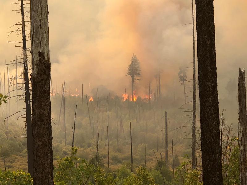
This is what I saw!
Taken on the 2nd September, 2018 at 21:44 PDT
Apparently, a short while previously the wind had blown down a tree that had fallen across some high-voltage power lines causing sparking that had, in turn, ignited the extremely dry grassland.
The fire was between Oxyoke Road and Three Pines Road and roughly 2 miles from us line of sight.
That explained why some thirty minutes before, in the last of the light of the setting sun, there had been a number of helicopter flights come across us en route to dropping fire retardant close by. It hadn’t occurred to me that it was an incident so close to us.
Many of us living nearby then called each other to spread the word.
Jeannie and I, in turn, drew up an evacuation checklist and started getting things ready. More importantly, getting ourselves psychologically prepared to have to vacate the property at very short notice: Jeannie and me: six dogs; two horses; two parakeets; three cats; two chickens!
Thankfully an order to evacuate did not come during the night.
So yesterday morning I grabbed my bike and rode to Oxyoke Road. On the way I stopped to photograph the smoke in the air.
Three Pines Road looking to the East.
Once at Oxyoke Road I chatted to a search and rescue volunteer on duty controlling the traffic.
His report, as of 11:30 on September 3rd, was that the fire was just 15% contained, was “pretty active”, and that they were keeping an eye on the winds that were expected to be rather gusty later on that afternoon. I am writing this at 13:40 on the 3rd and the present winds are 6 mph, gusting 12 mph, from the North-West.
I rode back home to brief Jeannie and found her working her way through an idea for evacuating the dogs!
H’mmm! I am not sure Pedy is getting the message!
But a few words from Sweeny seemed to sort things out.
So there you are my good people, a post about dogs! Sort of!
Fingers crossed we will speak again tomorrow!
Assuming we don’t have a repeat of last night’s spectacular sights!!
Photo taken by Holmes Ariel of the Hugo Road Neighbourhood Watch group.
Jeannie and I decided to take a few hours away from the house and go and do some local exploring.
Just 10 miles North of us, indeed the next exit (71) from Highway I-5, is the famous Grave Creek Covered Bridge.
We parked up and soaked it all in.
While there was an information board next to the bridge it was very easy to find the details online on the Southern Oregon travel site.
The Grave Creek Covered Bridge is one of the few covered bridges that remain in southern Oregon. From Vancouver B.C. to the Mexican border, it is the only one visible from the I-5 freeway. Be sure to visit the Applegate Trail Interpretive Center while in Sunny Valley. It provides a first hand look into the local area, history, fabulous displays, theatre & more.
In the fall of 1846, the first emigrant train from Fort Hall, Idaho, to travel the southern route to the Willamette Valley camped on the north side of this creek, then Woodpile Creek. Martha Leland Crowley, 16 years old died of typhoid fever during this encampment and was buried 150 feet north of the creek on the east side or a white oak tree that was later removed for the present roadway, Thus the name “Grave Creek”.
When James H. Twogood laid out his land claim in the fall of 1851 and filed it on May 1st 1852, he named it the Grave Creek Ranch in memory of that unfortunate incident.
McDonough Harkness, his partner, was the first postmaster of Josephine County in the newly named town of Leland on March 28,1855. Harkness was killed by the Indians in April 1856 while riding dispatch for the Army during the second Indian War of southern Oregon which started in October of 1855.
The bridge was built in 1920 and is 105 feet long.
Unsurprisingly, the creek had very little water in it.
But that didn’t diminish in the slightest the magic of this place out in the vast Oregon countryside.
A covered bridge is a timber-truss bridge with a roof and siding which, in most covered bridges, create an almost complete enclosure. The purpose of the covering is to protect the wooden structural members from the weather. Uncovered wooden bridges typically have a lifespan of only 10 to 15 years because of the effects of rain and sun. The brief moment of relative privacy while crossing the bridges earned them the name “Kissing Bridges”.
The latest news is that our Klondike Fire is now burning an area larger than 100,000 acres. Or to use the words from the incident webpage(my emphasis):
The Taylor Creek and Klondike Fires were split into zones on Saturday, Aug. 18. The fires are now referred to as “Taylor Creek Fire” and “Klondike Fire East,” managed by the Northwest Incident Management Team 12 out of Lake Selmac, and “Klondike Fire West” managed by California Interagency Incident Management Team 4 out of Gold Beach. A transfer of command of the Klondike West Zone will occur at 6:00 AM Friday when the Southern Area Red Team who arrived on Wednesday will take over.
As of the morning of Aug. 30, the Taylor Creek Fire is estimated 52,839 acres and is 95 percent contained. The Klondike Fire is estimated at 100,996 acres and is 40 percent contained. There are 1,214 personnel working on the Klondike Fire and 126 personnel assigned to the Taylor Creek Fire.
Courtesy Jeffersen Public Radio
Then just over a week ago, The Conversation blogsite published a reminder that I wanted to share with you today, under the permissions offered by The Conversation site.
ooOOoo
Many native animals and birds thrive in burned forests, research shows
But the idea that wildfires should be suppressed by logging the forest is far too simplistic. Most scientists agree that large hot wildfires produce many benefits for North American forests. Notably, they create essential habitat for many native species.
Fifteen years of research on Spotted Owls – a species that has played an oversized role in shaping U.S. forest management policies and practices for the past several decades – directly contradicts the argument that logging is needed to protect wildlife from fires. Wildlife biologists, including me, have shown in a string of peer-reviewed studies, that wildfires have little to no effect on Spotted Owls’ occupancy, reproduction or foraging, and even provide benefits to the owls.
The Northern Spotted Owl in the Pacific Northwest was listed as threatened under the Endangered Species Act in 1990. At that point, about 90 percent of U.S. old-growth forest had already been lost to logging. Every year in the 1980s the U.S. Forest Service sold about 7 to 12 billion board feet of public lands timber.
Figure 1. National forest timber sales (1905–2017). FY 1905-2017 National Summary Cut and Sold Data USDA Forest Service
Listing the owl drew attention to the dramatic decline of old-growth forest ecosystems due to 50 years of unsustainable logging practices. In response the U.S. Forest Service adopted new regulations that included fewer clearcuts, less cutting of trees over 30 inches in diameter and fewer cuts that opened up too much of the forest canopy. These policies, along with vast depletion of old-growth forests, reduced logging on Forest Service lands to about 2 billion board feet per year.
During the 1990s, national forest management policy for the Northern Spotted Owl included creating old-growth reserves and designating critical habitat where logging was restricted – mostly within half a mile of a Spotted Owl nest. In spite of these protections, populations of Northern Spotted Owls, as well as California and Mexican Spotted Owls, continued to decline on forest lands outside national parks. This was most likely due to ongoing logging outside of their protected nesting areas in the owls’ much larger year-round home ranges.
Fire and owls
Over the years the Forest Service shifted away from treating Spotted Owls as symbols of old-
Historical range (burgundy) of the Northern Spotted Owl, which also extended north into British Columbia. One hundred fifty years of logging, agriculture and urbanization have reduced the amount of old growth forest (potential Spotted Owl habitat) in this zone by 85-90 percent. NASA Earth Observatory
growth forest biodiversity, and instead started to cite them as an excuse for more logging. The idea that forest fires were a threat to Spotted Owls was first proposed in 1992 by agency biologists and contract researchers. In a status assessment of the California Spotted Owl, these scientists speculated that fires might be as damaging as clearcuts to the owls.
This perspective gained popularity within the Forest Service over the next 10 years and led to increased logging on public lands that degraded old-growth habitat for Spotted Owls.
Academic scientists, including some with Forest Service funding, published peer-reviewed studies of Spotted Owls and fire in 2002, 2009, 2011 and 2012. All four studies showed either no effects from fire or positive benefits from fire for Spotted Owls. Subsequent research on Spotted Owls in fire-affected forests has showed repeatedly that the owls can persist and thrive in burned landscapes.
(The U.S. Forest Service says wildfires harm wildlife habitat, but wildfires actually create rare and important habitat.)
Many wild species thrive in burned landscapes
I recently conducted a systematic review and meta-analysis that summarized all available scientific research on the effects of wildfires on Spotted Owl ecology. It found that Spotted Owls are usually not significantly affected by mixed-severity forest fire. Mixed-severity forest fire, which includes large patches with 100 percent tree mortality, is how wildfires in western forests naturally burn. The preponderance of evidence indicated that mixed-severity wildfire has more benefits than costs for Spotted Owls.
In 2017 I submitted an early version of this analysis with the same conclusions to the U.S. Fish and Wildlife Service during the agency’s peer-review process for its Conservation Objectives Report for the California Spotted Owl. My conclusions were not included in the final report.
Decades of science have shown that forest fires – including large hot fires – are an essential part of western U.S. forest ecosystems and create highly biodiverse wildlife habitat. Many native animals thrive in the years and decades after large intense fires, including deer, bats, woodpeckers and songbirds as well as Spotted Owls. Additionally, many native species are only found in the snag forest habitat of dead and dying trees created by high-severity wildfire.
Pileated woodpeckers excavate nests within snags, bringing life to charred forests in Oregon. NASA/S. Russell, CC BY-ND
Wildfires threaten homes, but wildlife and water supplies benefit
It is also time to reform Forest Service management goals to emphasize carbon capture, biodiversity, outdoor recreation and water supply as the most important ecosystem services provided by national forest lands. These services are enhanced by wildfires, not by logging.
ooOOoo
These last two paragraphs are key lessons: 1. Logging does not stop the biggest, hottest fires, and, 2. It is time to change the goals under which our forests are managed emphasising carbon capture, biodiversity, recreation and water supplies!


 on the