A more intimate look at the water of Arizona.
Yesterday, I published a recent Tomgram essay by William deBuys: Goodbye to All That (Water). The essence of what William was presenting was that, “The crucial question for Phoenix, for the Colorado, and for the greater part of the American West is this: How long will the water hold out?”
Also in yesterday’s Learning from Dogs post, I closed with the statement, “If readers will forgive me, I will continue the theme tomorrow with a rather more personal perspective.”
I have decided to delay the ‘personal’ aspect to today’s post until the very end. So back to Arizona’s water.
As an indication that this is not a new problem, I recently came across an article that was published in The Arizona Republic by Shaun McKinnon in August 2009. It was called Unabated use of groundwater threatens Arizona’s future. Here’s how that article opened:
Thirty years after Arizona tried to stop cities and towns from using up their groundwater, the state still can’t shake its thirst for one of its most finite resources.
The steady drain on underground reserves grows out of two realities: Canals and pipelines don’t reach far enough to deliver surface water to everyone, and laws don’t reach far enough to stop people from drilling.
If the groundwater addiction continues unabated and under-regulated, the effects will be broad and potentially disastrous: Scarcer supplies could push rates higher and create uncertainty about water availability, discouraging new business and slowing economic growth. If wells start to run dry and aquifers collapse, the landscape could be dotted with fissures and sinkholes.
Lawmakers adopted some of the nation’s most progressive water-protection laws to avert such crises, but the laws excluded rural areas and allowed changes that let cities and subdivisions resume well-drilling, further depleting exhaustible aquifers.
Meanwhile, the renewable resource intended to replace groundwater – surface water fed by the annual runoff of mountain snow – can’t meet the demand of urban areas too far from the delivery canals.
The result is holes in the state’s water bucket that are spreading as fast as the holes in the ground.
Then good friend, Dan Gomez sent me this link: Arizona’s Water: Uses and Sources. I would like to cover some of the information contained on that website.
Arizona’s Water: Uses and Sources
A land’s carrying capacity has always been determined by its access to usable water. Humans use water primarily for irrigation, industry, drinking water, and sanitation. Millions of non-human species depend on water for life itself. Only 1% of the earth’s water is freshwater, to be shared among more than 7 billion people and all freshwater aquatic ecosystems in the world. It is perhaps the most precious resource on the planet.
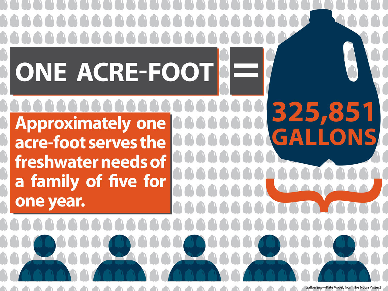
Large volumes of water are most commonly measured in acre-feet. One acre-foot is the amount of water required to cover one acre of area to the depth of one foot: 325,851 gallons. Approximately one acre-foot serves the needs of a family of five for one year. Arizona is one of the driest states in the U.S., and one of the fastest-growing. Arizona’s current population is over 6 million (2010 Census) and is projected to grow to as many as 9.5 million people by 2025. Encompassing four deserts, Arizona receives a statewide average of only 12.5 inches of rain per year. Our climate presents intense challenges in balancing our water needs between ourselves, our neighbors, and our riparian ecosystems. Water has defined our past and will determine our future.
“Water has defined our past and will determine our future”!
Let me skip a couple of paragraphs and continue, thus:
Water Budget: Usage and recharge
How much water do we use?
Based on Arizona Department of Water Resources (ADWR) data from 2001–2005, Arizona uses approximately 6.96 million acre-feet of water annually. A 2008 estimate by the University of Arizona Water Resources Research Center places that value as high as 8 million acre-feet. Collaborative estimates place the actual water used in Arizona at between 7.25 million and 7.75 million acre-feet annually. That’s about 2.4–2.5 trillion gallons a year.
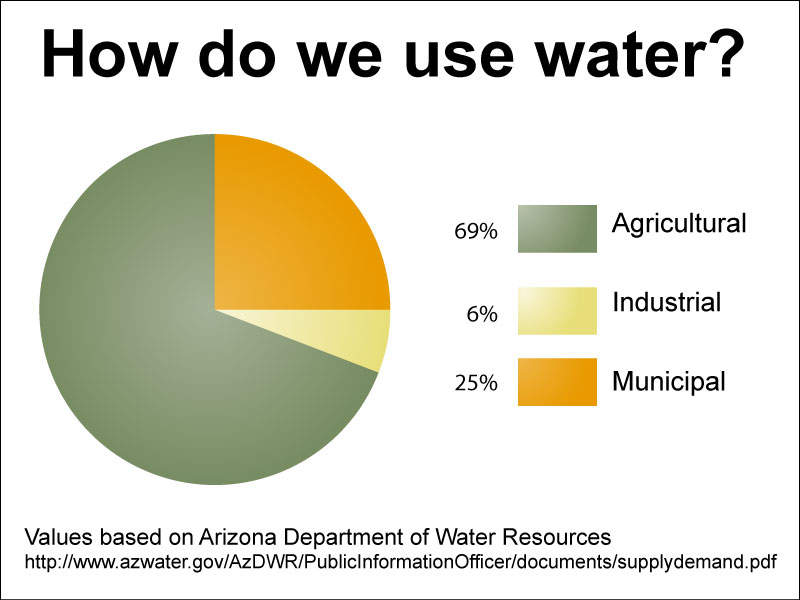
How do we use water?
Water in Arizona is used for cultural purposes (for and by people) and for in-stream uses, such as for the support of fish and riparian ecosystems.
Again, skipping forward.
Water Sources
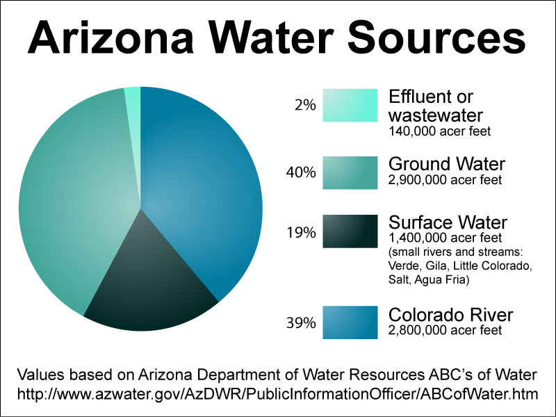
Arizona gets water from three major sources: surface water (which includes Colorado River water and water from other major rivers and streams), groundwater, and effluent or reclaimed water.
Groundwater
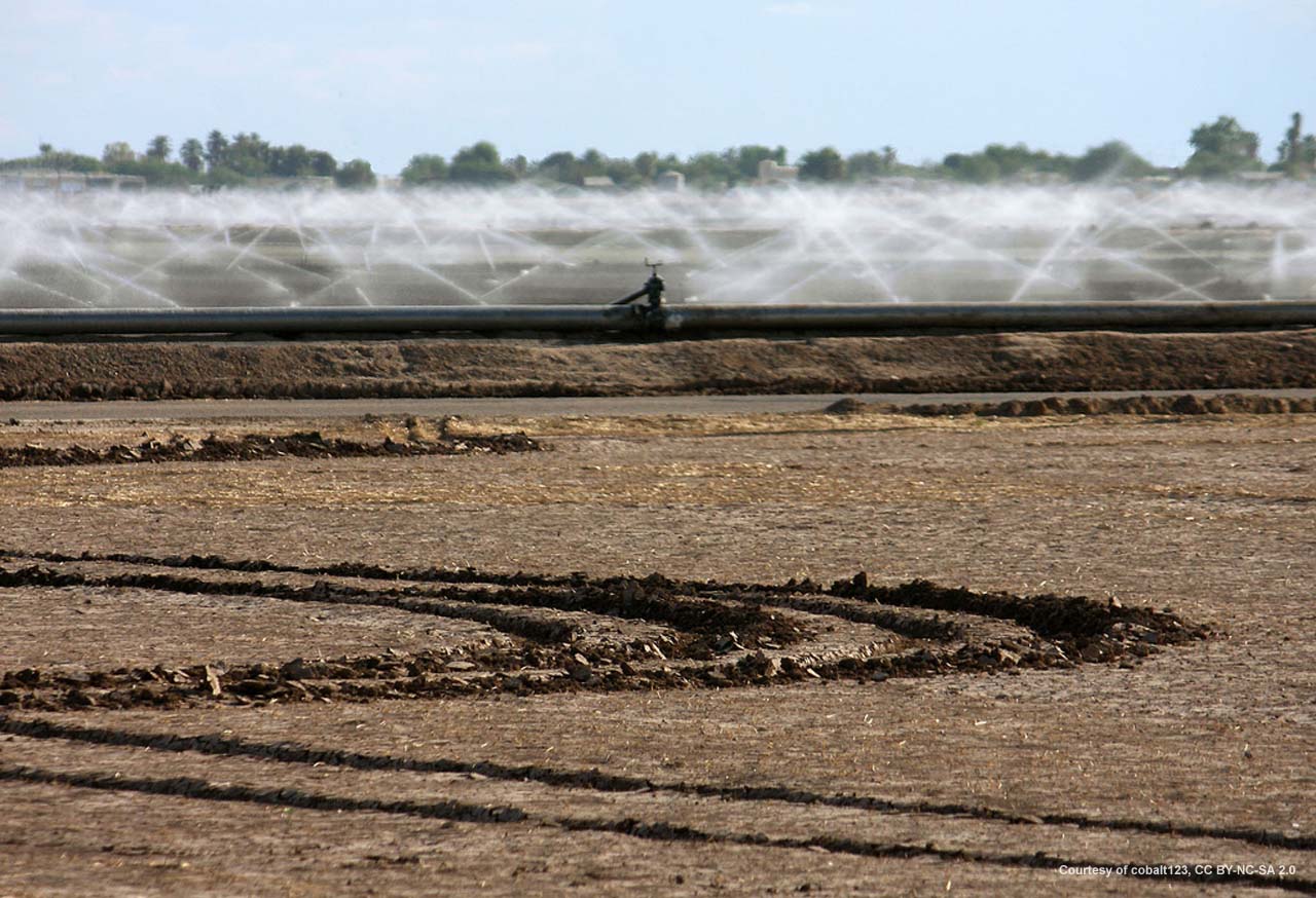
About 43% of the state’s water use comes from groundwater sources. Groundwater is found beneath the earth’s surface in natural reservoirs called aquifers. In most cases the aquifers that store water have been in place for millions of years. Throughout the 20th and 21st centuries, groundwater has been pumped out more rapidly than it has been replenished, creating a condition called overdraft. Though a large amount of water remains stored in Arizona’s aquifers, its availability is limited by location, depth and quality. By continuing to overdraft the state’s groundwater supplies, we challenge our ability to ensure a secure water supply for the future. In recognition of this threat, Arizona implemented the Groundwater Management Code in 1980. The Groundwater Code promotes water conservation and long-range planning of our water resources.
Colorado River Water
A separate category of surface water in Arizona is the water supplied through the Colorado River. The federal government constructed a system of reservoirs on the river to harness its supplies for use in several states. Arizona, California, Nevada, New Mexico, Utah, Colorado, Wyoming, and Mexico share the river’s resources. Rights to use Colorado River water are quantified by a string of legal authorities known as the “Law of the River.” Based on this body of law, Arizona has the right to use 2.8 million acre-feet annually of Colorado River water. Mohave, La Paz, and Yuma county water users rely on Colorado River as their principal water supply. When fully utilized, the Central Arizona Project (CAP) will deliver an annual average of 1.5 million acre-feet of Colorado River water to Maricopa, Pinal and Pima Counties.
Other Surface Water
Surface water from lakes, rivers, and streams is Arizona’s major renewable water resource. However, because of our desert climate, the amount of surface water available can vary dramatically from year to year, season to season, and place to place. In order to make the best use of the surface water when and where it is needed, storage reservoirs and delivery systems have been constructed throughout the state. Most notable are the major reservoir storage systems located on the Salt, Verde, Gila and Agua Fria rivers. Almost all of the natural surface water in Arizona has been developed.
Effluent
Reclaimed water, or effluent, is the one increasing water source in our state. As our population and water use grows, more treated wastewater will be available. Reclaimed water is treated to a quality that can be used for purposes such as agriculture, golf courses, parks, industrial cooling, or maintenance of wildlife areas.
Information made available by the Arizona Department of Water Resources and the University of Arizona Water Resources Research Center.
Since it is impossible to measure the exact values of water used across a state, some variance of values must be tolerated.
oooOOOooo
So take the message from yesterday’s post and then from above: “Throughout the 20th and 21st centuries, groundwater has been pumped out more rapidly than it has been replenished, creating a condition called overdraft. Though a large amount of water remains stored in Arizona’s aquifers, its availability is limited by location, depth and quality. By continuing to overdraft the state’s groundwater supplies, we challenge our ability to ensure a secure water supply for the future.“, and remember that 2 + 2 = 4! I.e. the power of logic.
Now to close with that personal perspective.
When Jean and I were living in Payson, Arizona, we were close to town but not so close as to be on Payson City’s water supply. Thus we had a well on our land. If I recall, the depth of the drilled well was about 250 feet and the water level was about 80 feet below ground surface. We had been told from the house survey that the ‘normal’ water level was about 35 feet down. While we were there the water level slowly, but steadily, continued to drop.
We were both very happy in Payson; indeed it is where Jean and I were married.
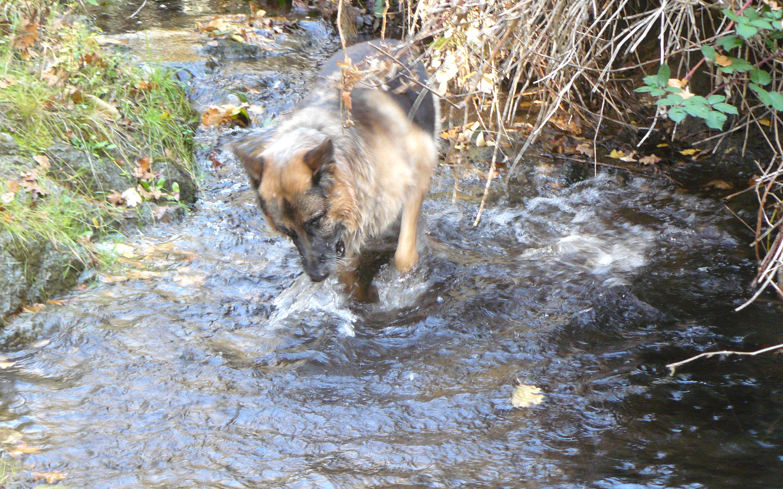
However, one night, I would guess last June, 2012, I had this weird dream that I had gone to the bathroom during the night, turned on the cold-water tap and nothing had flowed out. Bizarre dream, wouldn’t you say! But even more bizarre was that the image of no water was in my mind when I awoke in the morning, and I couldn’t shrug off a distinct feeling of disquiet. That all lead to us coming up to Oregon, finding this wonderful property with an all-year creek, Bummer Creek, running through our land, and moving in on October 25th, 2012.
Funny old world at times!